Yermentau elevation
Yermentau (Aqmola), Kazakhstan elevation is 392 meters and Yermentau elevation in feet is 1286 ft above sea level [src 1]. Yermentau is a populated place (feature code) with elevation that is 34 meters (112 ft) bigger than average city elevation in Kazakhstan.
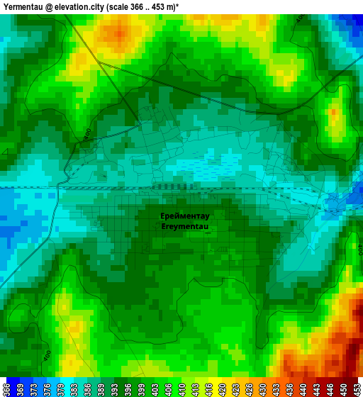
Below is the Elevation map of Yermentau, which displays elevation range with different colors. Scale of the first map is from 366 to 453 m (1201 to 1486 ft) with average elevation of 397.7 meters (=1305 ft) [note 1]
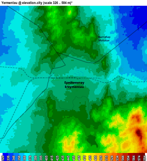
These maps also provides idea of topography and contour of this city, they are displayed at different zoom levels. More info about maps, scale and edge coordinates you can find below images.
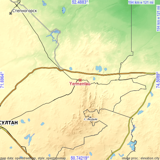
| \ | Map #1 | Map #2 | Topo.Map |
| Scale [m] | 366..453 m | 326..584 m | × |
| Scale [ft] | 1201..1486 ft | 1070..1916 ft | × |
| Average | 397.7 m = 1305 ft | 397.9 m = 1305 ft | × |
| Width | 6.07 km = 3.8 mi | 12.13 km = 7.5 mi | 194.1 km = 120.6 mi |
| Height | 6.07 km = 3.8 mi | 12.13 km = 7.5 mi | 194.1 km = 120.6 mi |
| ↑Max Latitude | 51.650914° | 51.678172° | 52.4883° |
| Latitude at center | 51.62364° | 51.62364° | 51.62364° |
| ↓Min Latitude | 51.596349° | 51.569043° | 50.74219° |
| ← Min Longitude | 73.058705° | 73.014759° | 71.6964° |
| Longitude center | 73.10265° | 73.10265° | 73.10265° |
| →Max Longitude | 73.146595° | 73.190541° | 74.5089° |
Nearby cities:
Cities around Yermentau sort by population:
• Nur-Sultan elevation 358 m
125 km,  246°
246°
• Ekibastuz 203 m
153.5 km,  85°
85°
• Stepnogorsk 311 m
116.3 km,  314°
314°
• Aktau 503 m
154.5 km,  180°
180°
• Aksu 278 m
120.2 km,  319°
319°
• Osakarovka 506 m
123.7 km,  197°
197°
• Bestobe 174 m
97.2 km,  359°
359°
• Shortandy 375 m
145.6 km,  273°
273°
• Zholymbet 329 m
96.7 km,  277°
277°
• Zavodskoy 264 m
120 km, 321°
• Kushoky 516 m
156.3 km,  172°
172°
• Akkol 381 m
153.8 km,  285°
285°
Multilingual:
 En español:
Yermentau elevación 392 m.
 En France:
Yermentau élévation 392 m.
 Auf Deutsch:
Yermentau höhe über dem Meeresspiegel ist 392 m.

Sources and notes:
- [note 1] Map square and city borders are not equal. Map elevation data is calculated only from area inside that square.
- [src 1] Elevation data from geonames database provided with same terms of usage.
- [src 2] The elevation map of Yermentau is generated using elevation data from NASA's 3 arcsec (90m) resolution SRTM data.
- [src 3] Base (background) map © OpenStreetMap contributors tiles are generated by Geofabrik and OpenTopoMap.
Copyright & License:
This Yermentau Elevation Map is licensed under CC BY-SA. You may reuse any part from this page, if you give a proper credit by linking to this URL:
 More info on terms of use page.