Akkol elevation
Akkol (Aqmola), Kazakhstan elevation is 381 meters and Akkol elevation in feet is 1250 ft above sea level [src 1]. Akkol is a seat of a second-order administrative division (feature code) with elevation that is 23 meters (75 ft) bigger than average city elevation in Kazakhstan.
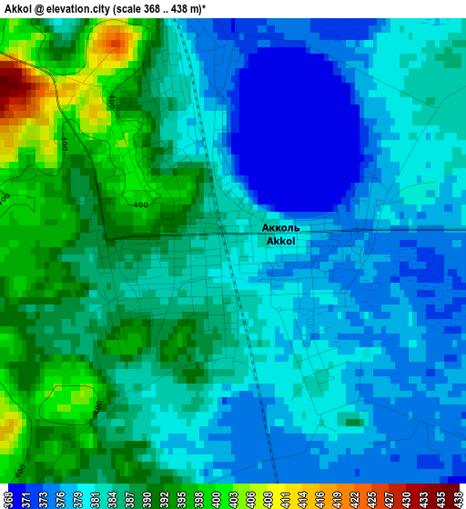
Below is the Elevation map of Akkol, which displays elevation range with different colors. Scale of the first map is from 368 to 438 m (1207 to 1437 ft) with average elevation of 384.1 meters (=1260 ft) [note 1]
These maps also provides idea of topography and contour of this city, they are displayed at different zoom levels. More info about maps, scale and edge coordinates you can find below images.
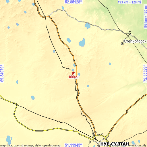
| \ | Map #1 | Topo.Map |
| Scale [m] | 368..438 m | × |
| Scale [ft] | 1207..1437 ft | × |
| Average | 384.1 m = 1260 ft | × |
| Width | 6.02 km = 3.7 mi | 192.6 km = 119.7 mi |
| Height | 6.02 km = 3.7 mi | 192.5 km = 119.6 mi |
| ↑Max Latitude | 52.020791° | 52.85128° |
| Latitude at center | 51.99374° | 51.99374° |
| ↓Min Latitude | 51.966673° | 51.11945° |
| ← Min Longitude | 70.903095° | 69.54079° |
| Longitude center | 70.94704° | 70.94704° |
| →Max Longitude | 70.990985° | 72.35329° |
Nearby cities:
Cities around Akkol sort by population:
• Nur-Sultan elevation 358 m
96.8 km,  159°
159°
• Shchuchinsk 405 m
116.7 km,  333°
333°
• Stepnogorsk 311 m
75.1 km,  58°
58°
• Makinsk 380 m
79.6 km, 333°
• Aksu 278 m
85.1 km,  53°
53°
• Shortandy 375 m
32.9 km,  174°
174°
• Zholymbet 329 m
59.5 km,  118°
118°
• Būrabay 321 m
128.5 km,  340°
340°
• Astrakhan 302 m
94.4 km,  236°
236°
• Zavodskoy 264 m
90 km, 53°
• Stepnyak 366 m
94.1 km,  353°
353°
• Egindiköl 340 m
145.7 km,  224°
224°
Multilingual:
 En español:
Akkol elevación 381 m.
 En France:
Akkol élévation 381 m.


Sources and notes:
- [note 1] Map square and city borders are not equal. Map elevation data is calculated only from area inside that square.
- [src 1] Elevation data from geonames database provided with same terms of usage.
- [src 2] The elevation map of Akkol is generated using elevation data from NASA's 3 arcsec (90m) resolution SRTM data.
- [src 3] Base (background) map © OpenStreetMap contributors tiles are generated by Geofabrik and OpenTopoMap.
Copyright & License:
This Akkol Elevation Map is licensed under CC BY-SA. You may reuse any part from this page, if you give a proper credit by linking to this URL:
 More info on terms of use page.