Egindiköl elevation
Egindiköl (Aqmola), Kazakhstan elevation is 340 meters and Egindiköl elevation in feet is 1115 ft above sea level [src 1]. Egindiköl is a populated place (feature code) with elevation that is 18 meters (59 ft) smaller than average city elevation in Kazakhstan.
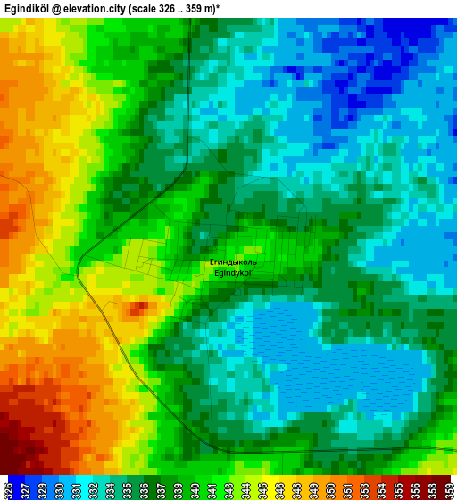
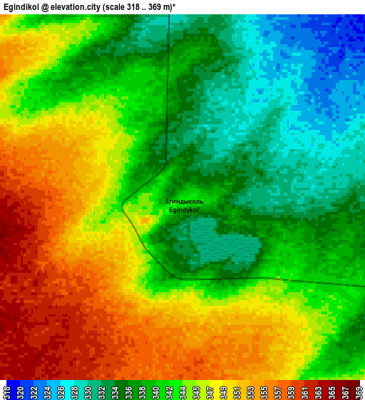
Below is the Elevation map of Egindiköl, which displays elevation range with different colors. Scale of the first map is from 326 to 359 m (1070 to 1178 ft) with average elevation of 338.3 meters (=1110 ft) [note 1]
These maps also provides idea of topography and contour of this city, they are displayed at different zoom levels. More info about maps, scale and edge coordinates you can find below images.
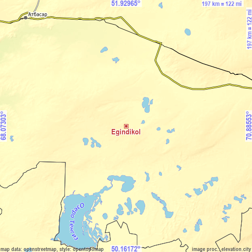
| \ | Map #1 | Map #2 | Topo.Map |
| Scale [m] | 326..359 m | 318..369 m | × |
| Scale [ft] | 1070..1178 ft | 1043..1211 ft | × |
| Average | 338.3 m = 1110 ft | 342.6 m = 1124 ft | × |
| Width | 6.14 km = 3.8 mi | 12.29 km = 7.6 mi | 196.6 km = 122.2 mi |
| Height | 6.14 km = 3.8 mi | 12.29 km = 7.6 mi | 196.6 km = 122.2 mi |
| ↑Max Latitude | 51.081735° | 51.109334° | 51.92965° |
| Latitude at center | 51.05412° | 51.05412° | 51.05412° |
| ↓Min Latitude | 51.026488° | 50.99884° | 50.16172° |
| ← Min Longitude | 69.435335° | 69.391389° | 68.07303° |
| Longitude center | 69.47928° | 69.47928° | 69.47928° |
| →Max Longitude | 69.523225° | 69.567171° | 70.88553° |
Nearby cities:
Cities around Egindiköl sort by population:
• Nur-Sultan elevation 358 m
138 km,  84°
84°
• Atbasar 283 m
114.1 km,  317°
317°
• Makinsk 380 m
187 km,  20°
20°
• Kīevka 397 m
170.4 km,  121°
121°
• Shortandy 375 m
127.3 km,  55°
55°
• Zholymbet 329 m
172.8 km, 63°
• Astrakhan 302 m
57.4 km, 22°
• Balkashino 371 m
170.3 km,  342°
342°
• Shantobe 385 m
179.7 km,  330°
330°
• Zhaqsy 392 m
177.5 km,  302°
302°
• Akkol 381 m
145.7 km,  44°
44°
• Atbasar 280 m
114.8 km, 316°
Multilingual:
 En español:
Egindiköl elevación 340 m.
 En France:
Egindiköl élévation 340 m.
 Auf Deutsch:
Egindiköl höhe über dem Meeresspiegel ist 340 m.

Sources and notes:
- [note 1] Map square and city borders are not equal. Map elevation data is calculated only from area inside that square.
- [src 1] Elevation data from geonames database provided with same terms of usage.
- [src 2] The elevation map of Egindiköl is generated using elevation data from NASA's 3 arcsec (90m) resolution SRTM data.
- [src 3] Base (background) map © OpenStreetMap contributors tiles are generated by Geofabrik and OpenTopoMap.
Copyright & License:
This Egindiköl Elevation Map is licensed under CC BY-SA. You may reuse any part from this page, if you give a proper credit by linking to this URL:
 More info on terms of use page.