Atbasar elevation
Atbasar (Aqmola), Kazakhstan elevation is 283 meters and Atbasar elevation in feet is 928 ft above sea level [src 1]. Atbasar is a populated place (feature code) with elevation that is 75 meters (246 ft) smaller than average city elevation in Kazakhstan.
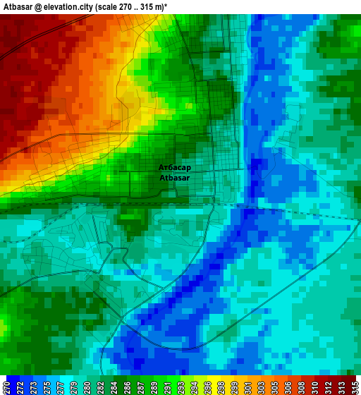
Below is the Elevation map of Atbasar, which displays elevation range with different colors. Scale of the first map is from 270 to 315 m (886 to 1033 ft) with average elevation of 284.7 meters (=934 ft) [note 1]
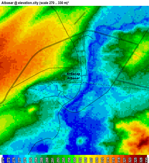
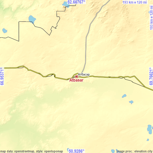
These maps also provides idea of topography and contour of this city, they are displayed at different zoom levels. More info about maps, scale and edge coordinates you can find below images.
| \ | Map #1 | Map #2 | Topo.Map |
| Scale [m] | 270..315 m | 270..330 m | × |
| Scale [ft] | 886..1033 ft | 886..1083 ft | × |
| Average | 284.7 m = 934 ft | 290.9 m = 954 ft | × |
| Width | 6.04 km = 3.8 mi | 12.09 km = 7.5 mi | 193.4 km = 120.2 mi |
| Height | 6.04 km = 3.8 mi | 12.09 km = 7.5 mi | 193.3 km = 120.1 mi |
| ↑Max Latitude | 51.833684° | 51.860832° | 52.66767° |
| Latitude at center | 51.80652° | 51.80652° | 51.80652° |
| ↓Min Latitude | 51.77934° | 51.752143° | 50.9286° |
| ← Min Longitude | 68.316015° | 68.272069° | 66.95371° |
| Longitude center | 68.35996° | 68.35996° | 68.35996° |
| →Max Longitude | 68.403905° | 68.447851° | 69.76621° |
Nearby cities:
Cities around Atbasar sort by population:
• Shchuchinsk elevation 405 m
176.6 km,  44°
44°
• Makinsk 380 m
167.7 km,  56°
56°
• Derzhavīnsk 247 m
162 km,  240°
240°
• Esil 221 m
135 km,  277°
277°
• Astrakhan 302 m
103.7 km,  107°
107°
• Balkashino 371 m
83.5 km,  18°
18°
• Shantobe 385 m
73.1 km,  350°
350°
• Zhaqsy 392 m
72.6 km, 279°
• Egindiköl 340 m
114.1 km,  137°
137°
• Krasnogorskiy 202 m
135 km,  291°
291°
• Volodarskoye 297 m
166.1 km, 354°
• Atbasar 280 m
2 km,  248°
248°
Multilingual:
 En español:
Atbasar elevación 283 m.
 En France:
Atbassar élévation 283 m.
 Auf Deutsch:
Atbassar höhe über dem Meeresspiegel ist 283 m.

Sources and notes:
- [note 1] Map square and city borders are not equal. Map elevation data is calculated only from area inside that square.
- [src 1] Elevation data from geonames database provided with same terms of usage.
- [src 2] The elevation map of Atbasar is generated using elevation data from NASA's 3 arcsec (90m) resolution SRTM data.
- [src 3] Base (background) map © OpenStreetMap contributors tiles are generated by Geofabrik and OpenTopoMap.
Copyright & License:
This Atbasar Elevation Map is licensed under CC BY-SA. You may reuse any part from this page, if you give a proper credit by linking to this URL:
 More info on terms of use page.