Makinsk elevation
Makinsk (Aqmola), Kazakhstan elevation is 380 meters and Makinsk elevation in feet is 1247 ft above sea level [src 1]. Makinsk is a populated place (feature code) with elevation that is 22 meters (72 ft) bigger than average city elevation in Kazakhstan.
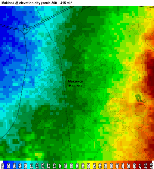
Below is the Elevation map of Makinsk, which displays elevation range with different colors. Scale of the first map is from 360 to 415 m (1181 to 1362 ft) with average elevation of 381.3 meters (=1251 ft) [note 1]
These maps also provides idea of topography and contour of this city, they are displayed at different zoom levels. More info about maps, scale and edge coordinates you can find below images.

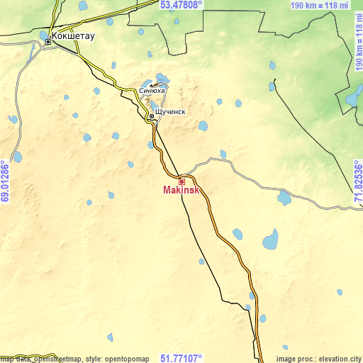
| \ | Map #1 | Map #2 | Topo.Map |
| Scale [m] | 360..415 m | 347..472 m | × |
| Scale [ft] | 1181..1362 ft | 1138..1549 ft | × |
| Average | 381.3 m = 1251 ft | 387.5 m = 1271 ft | × |
| Width | 5.93 km = 3.7 mi | 11.86 km = 7.4 mi | 189.8 km = 117.9 mi |
| Height | 5.93 km = 3.7 mi | 11.86 km = 7.4 mi | 189.8 km = 117.9 mi |
| ↑Max Latitude | 52.659563° | 52.68621° | 53.47808° |
| Latitude at center | 52.6329° | 52.6329° | 52.6329° |
| ↓Min Latitude | 52.606221° | 52.579525° | 51.77107° |
| ← Min Longitude | 70.375165° | 70.331219° | 69.01286° |
| Longitude center | 70.41911° | 70.41911° | 70.41911° |
| →Max Longitude | 70.463055° | 70.507001° | 71.82536° |
Nearby cities:
Cities around Makinsk sort by population:
• Kokshetau elevation 234 m
99.4 km,  316°
316°
• Shchuchinsk 405 m
37.1 km,  335°
335°
• Stepnogorsk 311 m
103.9 km,  107°
107°
• Akkol’ 261 m
91.9 km, 323°
• Aksu 278 m
106.1 km,  101°
101°
• Shortandy 375 m
111 km,  159°
159°
• Būrabay 321 m
50.6 km,  351°
351°
• Astrakhan 302 m
129.7 km,  199°
199°
• Balkashino 371 m
113.4 km,  263°
263°
• Zavodskoy 264 m
109.4 km, 99°
• Stepnyak 366 m
33.5 km,  47°
47°
• Akkol 381 m
79.6 km,  153°
153°
Multilingual:
 En español:
Makinsk elevación 380 m.
 En France:
Makinsk élévation 380 m.


Sources and notes:
- [note 1] Map square and city borders are not equal. Map elevation data is calculated only from area inside that square.
- [src 1] Elevation data from geonames database provided with same terms of usage.
- [src 2] The elevation map of Makinsk is generated using elevation data from NASA's 3 arcsec (90m) resolution SRTM data.
- [src 3] Base (background) map © OpenStreetMap contributors tiles are generated by Geofabrik and OpenTopoMap.
Copyright & License:
This Makinsk Elevation Map is licensed under CC BY-SA. You may reuse any part from this page, if you give a proper credit by linking to this URL:
 More info on terms of use page.