Shortandy elevation
Shortandy (Aqmola), Kazakhstan elevation is 375 meters and Shortandy elevation in feet is 1230 ft above sea level [src 1]. Shortandy is a populated place (feature code) with elevation that is 17 meters (56 ft) bigger than average city elevation in Kazakhstan.
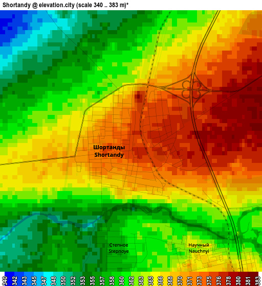
Below is the Elevation map of Shortandy, which displays elevation range with different colors. Scale of the first map is from 340 to 383 m (1115 to 1257 ft) with average elevation of 364.3 meters (=1195 ft) [note 1]
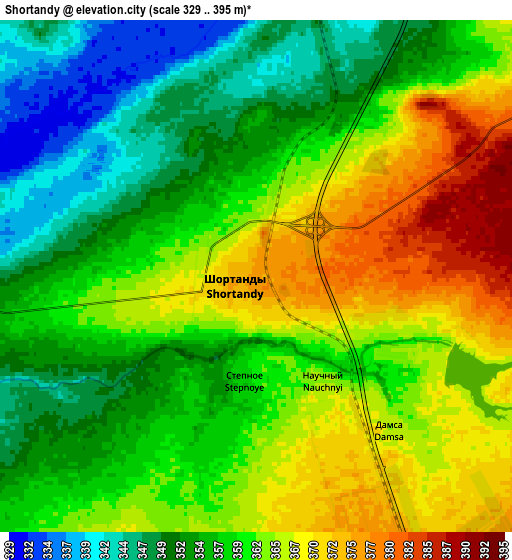
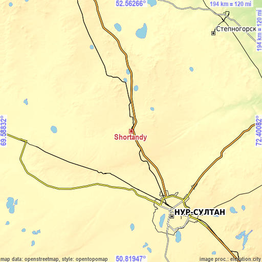
These maps also provides idea of topography and contour of this city, they are displayed at different zoom levels. More info about maps, scale and edge coordinates you can find below images.
| \ | Map #1 | Map #2 | Topo.Map |
| Scale [m] | 340..383 m | 329..395 m | × |
| Scale [ft] | 1115..1257 ft | 1079..1296 ft | × |
| Average | 364.3 m = 1195 ft | 359.9 m = 1181 ft | × |
| Width | 6.06 km = 3.8 mi | 12.11 km = 7.5 mi | 193.8 km = 120.4 mi |
| Height | 6.06 km = 3.8 mi | 12.11 km = 7.5 mi | 193.8 km = 120.4 mi |
| ↑Max Latitude | 51.726689° | 51.753901° | 52.56266° |
| Latitude at center | 51.69946° | 51.69946° | 51.69946° |
| ↓Min Latitude | 51.672215° | 51.644954° | 50.81947° |
| ← Min Longitude | 70.950625° | 70.906679° | 69.58832° |
| Longitude center | 70.99457° | 70.99457° | 70.99457° |
| →Max Longitude | 71.038515° | 71.082461° | 72.40082° |
Nearby cities:
Cities around Shortandy sort by population:
• Nur-Sultan elevation 358 m
65.7 km,  151°
151°
• Shchuchinsk 405 m
148 km,  338°
338°
• Stepnogorsk 311 m
94.5 km,  39°
39°
• Makinsk 380 m
111 km, 339°
• Yermentau 392 m
145.6 km,  93°
93°
• Aksu 278 m
105.8 km, 38°
• Zholymbet 329 m
49.7 km,  84°
84°
• Astrakhan 302 m
84.8 km,  257°
257°
• Zavodskoy 264 m
110.5 km, 39°
• Stepnyak 366 m
127 km,  353°
353°
• Egindiköl 340 m
127.3 km,  235°
235°
• Akkol 381 m
32.9 km, 354°
Multilingual:
 En español:
Shortandy elevación 375 m.
 En France:
Shortandy élévation 375 m.
 Auf Deutsch:
Shortandy höhe über dem Meeresspiegel ist 375 m.

Sources and notes:
- [note 1] Map square and city borders are not equal. Map elevation data is calculated only from area inside that square.
- [src 1] Elevation data from geonames database provided with same terms of usage.
- [src 2] The elevation map of Shortandy is generated using elevation data from NASA's 3 arcsec (90m) resolution SRTM data.
- [src 3] Base (background) map © OpenStreetMap contributors tiles are generated by Geofabrik and OpenTopoMap.
Copyright & License:
This Shortandy Elevation Map is licensed under CC BY-SA. You may reuse any part from this page, if you give a proper credit by linking to this URL:
 More info on terms of use page.