Kokshetau elevation
Kokshetau (Aqmola), Kazakhstan elevation is 234 meters and Kokshetau elevation in feet is 768 ft above sea level [src 1]. Kokshetau is a seat of a first-order administrative division (feature code) with elevation that is 124 meters (407 ft) smaller than average city elevation in Kazakhstan.
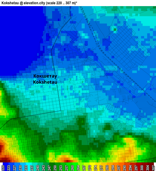
Below is the Elevation map of Kokshetau, which displays elevation range with different colors. Scale of the first map is from 220 to 307 m (722 to 1007 ft) with average elevation of 236.7 meters (=777 ft) [note 1]
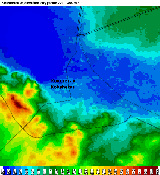
These maps also provides idea of topography and contour of this city, they are displayed at different zoom levels. More info about maps, scale and edge coordinates you can find below images.
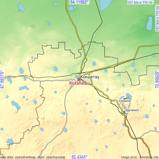
| \ | Map #1 | Map #2 | Topo.Map |
| Scale [m] | 220..307 m | 220..355 m | × |
| Scale [ft] | 722..1007 ft | 722..1165 ft | × |
| Average | 236.7 m = 777 ft | 251.8 m = 826 ft | × |
| Width | 5.84 km = 3.6 mi | 11.69 km = 7.3 mi | 187 km = 116.2 mi |
| Height | 5.84 km = 3.6 mi | 11.69 km = 7.3 mi | 187 km = 116.2 mi |
| ↑Max Latitude | 53.309595° | 53.335844° | 54.11582° |
| Latitude at center | 53.28333° | 53.28333° | 53.28333° |
| ↓Min Latitude | 53.257049° | 53.230752° | 52.4343° |
| ← Min Longitude | 69.356055° | 69.312109° | 67.99375° |
| Longitude center | 69.4° | 69.4° | 69.4° |
| →Max Longitude | 69.443945° | 69.487891° | 70.80625° |
Nearby cities:
Cities around Kokshetau sort by population:
• Shchuchinsk elevation 405 m
65.3 km,  126°
126°
• Makinsk 380 m
99.4 km,  136°
136°
• Akkol’ 261 m
13.4 km,  83°
83°
• Taiynsha 155 m
67.3 km,  21°
21°
• Būrabay 321 m
64.8 km,  110°
110°
• Balkashino 371 m
95.6 km,  207°
207°
• Smirnovo 135 m
136.9 km,  0°
0°
• Shantobe 385 m
123.6 km,  221°
221°
• Yavlenka 132 m
133.3 km,  332°
332°
• Stepnyak 366 m
105.3 km,  118°
118°
• Volodarskoye 297 m
86.1 km,  270°
270°
• Birlestik 234 m
76.9 km,  295°
295°
Multilingual:
 En español:
Kokshetau elevación 234 m.
 En France:
Kokchetaou élévation 234 m.
 Auf Deutsch:
Kökschetau höhe über dem Meeresspiegel ist 234 m.

Sources and notes:
- [note 1] Map square and city borders are not equal. Map elevation data is calculated only from area inside that square.
- [src 1] Elevation data from geonames database provided with same terms of usage.
- [src 2] The elevation map of Kokshetau is generated using elevation data from NASA's 3 arcsec (90m) resolution SRTM data.
- [src 3] Base (background) map © OpenStreetMap contributors tiles are generated by Geofabrik and OpenTopoMap.
Copyright & License:
This Kokshetau Elevation Map is licensed under CC BY-SA. You may reuse any part from this page, if you give a proper credit by linking to this URL:
 More info on terms of use page.