Volodarskoye elevation
Volodarskoye (Soltüstik Qazaqstan), Kazakhstan elevation is 297 meters and Volodarskoye elevation in feet is 974 ft above sea level [src 1]. Volodarskoye is a populated place (feature code) with elevation that is 61 meters (200 ft) smaller than average city elevation in Kazakhstan.
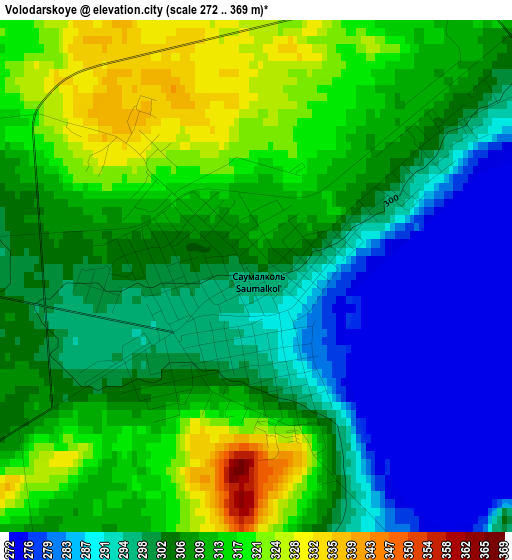
Below is the Elevation map of Volodarskoye, which displays elevation range with different colors. Scale of the first map is from 272 to 369 m (892 to 1211 ft) with average elevation of 304.5 meters (=999 ft) [note 1]
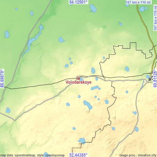
These maps also provides idea of topography and contour of this city, they are displayed at different zoom levels. More info about maps, scale and edge coordinates you can find below images.
| \ | Map #1 | Topo.Map |
| Scale [m] | 272..369 m | × |
| Scale [ft] | 892..1211 ft | × |
| Average | 304.5 m = 999 ft | × |
| Width | 5.84 km = 3.6 mi | 186.9 km = 116.1 mi |
| Height | 5.84 km = 3.6 mi | 186.9 km = 116.1 mi |
| ↑Max Latitude | 53.318959° | 54.12501° |
| Latitude at center | 53.2927° | 53.2927° |
| ↓Min Latitude | 53.266425° | 52.44385° |
| ← Min Longitude | 68.061055° | 66.69875° |
| Longitude center | 68.105° | 68.105° |
| →Max Longitude | 68.148945° | 69.51125° |
Nearby cities:
Cities around Volodarskoye sort by population:
• Kokshetau elevation 234 m
86.1 km,  90°
90°
• Shchuchinsk 405 m
144.6 km,  105°
105°
• Akkol’ 261 m
99.4 km, 89°
• Taiynsha 155 m
126 km,  60°
60°
• Sergeyevka 149 m
80 km,  324°
324°
• Būrabay 321 m
149 km,  98°
98°
• Balkashino 371 m
96.5 km,  153°
153°
• Novoishimskiy 184 m
89.5 km,  263°
263°
• Shantobe 385 m
93.4 km,  177°
177°
• Yavlenka 132 m
119.3 km,  11°
11°
• Timiryazevo 170 m
118.3 km,  295°
295°
• Birlestik 234 m
36.4 km,  26°
26°
Multilingual:
 En español:
Volodarskoye elevación 297 m.
 En France:
Volodarskoye élévation 297 m.
 Auf Deutsch:
Volodarskoye höhe über dem Meeresspiegel ist 297 m.
 На русском:
Володарское, Saumalkol’ высота над уровнем моря 297 м
Sources and notes:
- [note 1] Map square and city borders are not equal. Map elevation data is calculated only from area inside that square.
- [src 1] Elevation data from geonames database provided with same terms of usage.
- [src 2] The elevation map of Volodarskoye is generated using elevation data from NASA's 3 arcsec (90m) resolution SRTM data.
- [src 3] Base (background) map © OpenStreetMap contributors tiles are generated by Geofabrik and OpenTopoMap.
Copyright & License:
This Volodarskoye Elevation Map is licensed under CC BY-SA. You may reuse any part from this page, if you give a proper credit by linking to this URL:
 More info on terms of use page.