Novoishimskiy elevation
Novoishimskiy (Soltüstik Qazaqstan), Kazakhstan elevation is 184 meters and Novoishimskiy elevation in feet is 604 ft above sea level [src 1]. Novoishimskiy is a populated place (feature code) with elevation that is 174 meters (571 ft) smaller than average city elevation in Kazakhstan.
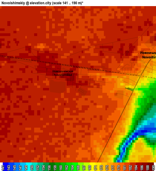
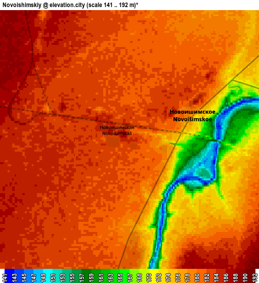
Below is the Elevation map of Novoishimskiy, which displays elevation range with different colors. Scale of the first map is from 141 to 190 m (463 to 623 ft) with average elevation of 180.3 meters (=592 ft) [note 1]
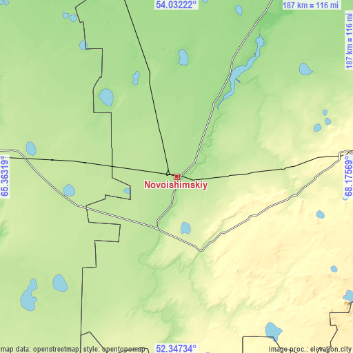
These maps also provides idea of topography and contour of this city, they are displayed at different zoom levels. More info about maps, scale and edge coordinates you can find below images.
| \ | Map #1 | Map #2 | Topo.Map |
| Scale [m] | 141..190 m | 141..192 m | × |
| Scale [ft] | 463..623 ft | 463..630 ft | × |
| Average | 180.3 m = 592 ft | 179.9 m = 590 ft | × |
| Width | 5.85 km = 3.6 mi | 11.71 km = 7.3 mi | 187.3 km = 116.4 mi |
| Height | 5.85 km = 3.6 mi | 11.71 km = 7.3 mi | 187.3 km = 116.4 mi |
| ↑Max Latitude | 53.224377° | 53.250679° | 54.03222° |
| Latitude at center | 53.19806° | 53.19806° | 53.19806° |
| ↓Min Latitude | 53.171726° | 53.145377° | 52.34734° |
| ← Min Longitude | 66.725495° | 66.681549° | 65.36319° |
| Longitude center | 66.76944° | 66.76944° | 66.76944° |
| →Max Longitude | 66.813385° | 66.857331° | 68.17569° |
Nearby cities:
Cities around Novoishimskiy sort by population:
• Esil elevation 221 m
140.4 km,  190°
190°
• Sergeyevka 149 m
86.9 km,  29°
29°
• Qusmuryn 114 m
166.6 km,  240°
240°
• Balkashino 371 m
153.1 km,  119°
119°
• Shantobe 385 m
125.5 km,  131°
131°
• Zhaqsy 392 m
147.9 km,  165°
165°
• Timiryazevo 170 m
64.1 km,  343°
343°
• Krasnogorskiy 202 m
107.2 km, 188°
• Karasu 206 m
104.9 km, 235°
• Troyebratskiy 161 m
145.6 km, 341°
• Volodarskoye 297 m
89.5 km,  83°
83°
• Birlestik 234 m
113.5 km,  67°
67°
Multilingual:
 En español:
Novoishimskiy elevación 184 m.
 En France:
Novoishimskiy élévation 184 m.
 Auf Deutsch:
Novoishimskiy höhe über dem Meeresspiegel ist 184 m.

Sources and notes:
- [note 1] Map square and city borders are not equal. Map elevation data is calculated only from area inside that square.
- [src 1] Elevation data from geonames database provided with same terms of usage.
- [src 2] The elevation map of Novoishimskiy is generated using elevation data from NASA's 3 arcsec (90m) resolution SRTM data.
- [src 3] Base (background) map © OpenStreetMap contributors tiles are generated by Geofabrik and OpenTopoMap.
Copyright & License:
This Novoishimskiy Elevation Map is licensed under CC BY-SA. You may reuse any part from this page, if you give a proper credit by linking to this URL:
 More info on terms of use page.