Mayqayyng elevation
Mayqayyng (Pavlodar Region), Kazakhstan elevation is 260 meters and Mayqayyng elevation in feet is 853 ft above sea level [src 1]. Mayqayyng is a populated place (feature code) with elevation that is 98 meters (322 ft) smaller than average city elevation in Kazakhstan.
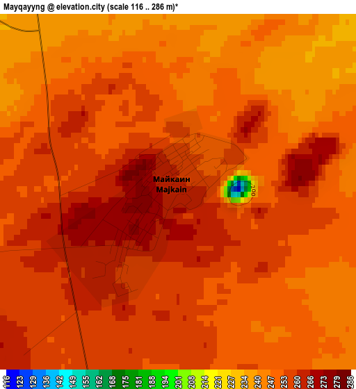
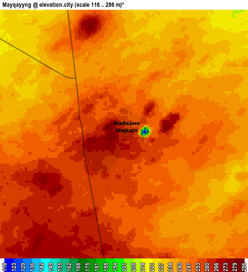
Below is the Elevation map of Mayqayyng, which displays elevation range with different colors. Scale of the first map is from 116 to 286 m (381 to 938 ft) with average elevation of 252.1 meters (=827 ft) [note 1]
These maps also provides idea of topography and contour of this city, they are displayed at different zoom levels. More info about maps, scale and edge coordinates you can find below images.
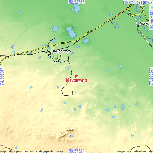
| \ | Map #1 | Map #2 | Topo.Map |
| Scale [m] | 116..286 m | 116..286 m | × |
| Scale [ft] | 381..938 ft | 381..938 ft | × |
| Average | 252.1 m = 827 ft | 245 m = 804 ft | × |
| Width | 6.09 km = 3.8 mi | 12.18 km = 7.6 mi | 194.8 km = 121 mi |
| Height | 6.09 km = 3.8 mi | 12.18 km = 7.6 mi | 194.8 km = 121 mi |
| ↑Max Latitude | 51.487183° | 51.514539° | 52.3276° |
| Latitude at center | 51.45981° | 51.45981° | 51.45981° |
| ↓Min Latitude | 51.432421° | 51.405016° | 50.5752° |
| ← Min Longitude | 75.758375° | 75.714429° | 74.39607° |
| Longitude center | 75.80232° | 75.80232° | 75.80232° |
| →Max Longitude | 75.846265° | 75.890211° | 77.20857° |
Nearby cities:
Cities around Mayqayyng sort by population:
• Pavlodar elevation 133 m
121.5 km,  41°
41°
• Ekibastuz 203 m
44.2 km,  311°
311°
• Aksu 123 m
100.8 km,  50°
50°
• Yermentau 392 m
187.6 km,  275°
275°
• Kurchatov 165 m
206.6 km,  112°
112°
• Irtyshsk 91 m
209.7 km,  353°
353°
• Qashyr 97 m
179.8 km,  6°
6°
• Leninskiy 109 m
111 km, 37°
• Bayanaul 474 m
74.5 km,  185°
185°
• Kalkaman 122 m
57 km,  15°
15°
• Belogor’ye 131 m
115.8 km,  86°
86°
• Prigorodnoye 678 m
197.1 km,  184°
184°
Multilingual:
 En español:
Mayqayyng elevación 260 m.
 En France:
Mayqayyng élévation 260 m.
 Auf Deutsch:
Mayqayyng höhe über dem Meeresspiegel ist 260 m.

Sources and notes:
- [note 1] Map square and city borders are not equal. Map elevation data is calculated only from area inside that square.
- [src 1] Elevation data from geonames database provided with same terms of usage.
- [src 2] The elevation map of Mayqayyng is generated using elevation data from NASA's 3 arcsec (90m) resolution SRTM data.
- [src 3] Base (background) map © OpenStreetMap contributors tiles are generated by Geofabrik and OpenTopoMap.
Copyright & License:
This Mayqayyng Elevation Map is licensed under CC BY-SA. You may reuse any part from this page, if you give a proper credit by linking to this URL:
 More info on terms of use page.