Pavlodar elevation
Pavlodar (Pavlodar Region), Kazakhstan elevation is 133 meters and Pavlodar elevation in feet is 436 ft above sea level [src 1]. Pavlodar is a seat of a first-order administrative division (feature code) with elevation that is 225 meters (738 ft) smaller than average city elevation in Kazakhstan.
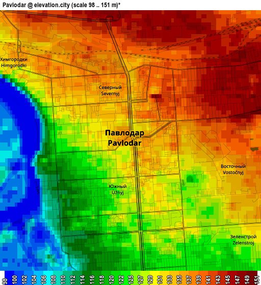
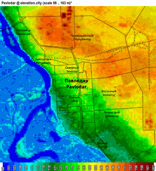
Below is the Elevation map of Pavlodar, which displays elevation range with different colors. Scale of the first map is from 98 to 151 m (322 to 495 ft) with average elevation of 128.9 meters (=423 ft) [note 1]
These maps also provides idea of topography and contour of this city, they are displayed at different zoom levels. More info about maps, scale and edge coordinates you can find below images.
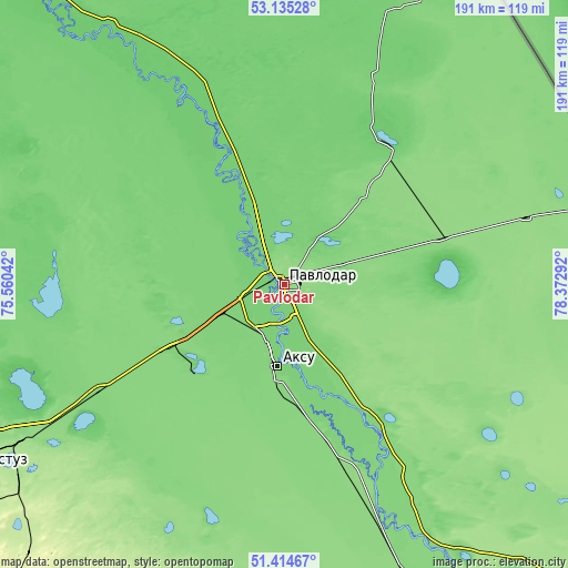
| \ | Map #1 | Map #2 | Topo.Map |
| Scale [m] | 98..151 m | 98..163 m | × |
| Scale [ft] | 322..495 ft | 322..535 ft | × |
| Average | 128.9 m = 423 ft | 125.5 m = 412 ft | × |
| Width | 5.98 km = 3.7 mi | 11.96 km = 7.4 mi | 191.3 km = 118.9 mi |
| Height | 5.98 km = 3.7 mi | 11.96 km = 7.4 mi | 191.3 km = 118.9 mi |
| ↑Max Latitude | 52.310206° | 52.337065° | 53.13528° |
| Latitude at center | 52.28333° | 52.28333° | 52.28333° |
| ↓Min Latitude | 52.256438° | 52.22953° | 51.41467° |
| ← Min Longitude | 76.922725° | 76.878779° | 75.56042° |
| Longitude center | 76.96667° | 76.96667° | 76.96667° |
| →Max Longitude | 77.010615° | 77.054561° | 78.37292° |
Nearby cities:
Cities around Pavlodar sort by population:
• Ekibastuz elevation 203 m
128.6 km,  241°
241°
• Aksu 123 m
27.2 km,  185°
185°
• Kurchatov 165 m
201.8 km,  147°
147°
• Irtyshsk 91 m
154.7 km,  319°
319°
• Qashyr 97 m
104.7 km,  326°
326°
• Leninskiy 109 m
13 km,  255°
255°
• Mayqayyng 260 m
121.5 km,  221°
221°
• Bestobe 174 m
263.7 km,  275°
275°
• Bayanaul 474 m
187.4 km,  207°
207°
• Kalkaman 122 m
73.9 km, 240°
• Zhelezinka 92 m
178.3 km, 321°
• Belogor’ye 131 m
90.7 km,  157°
157°
Multilingual:
 En español:
Pavlodar elevación 133 m.
 En France:
Pavlodar élévation 133 m.
 Auf Deutsch:
Pawlodar höhe über dem Meeresspiegel ist 133 m.

Sources and notes:
- [note 1] Map square and city borders are not equal. Map elevation data is calculated only from area inside that square.
- [src 1] Elevation data from geonames database provided with same terms of usage.
- [src 2] The elevation map of Pavlodar is generated using elevation data from NASA's 3 arcsec (90m) resolution SRTM data.
- [src 3] Base (background) map © OpenStreetMap contributors tiles are generated by Geofabrik and OpenTopoMap.
Copyright & License:
This Pavlodar Elevation Map is licensed under CC BY-SA. You may reuse any part from this page, if you give a proper credit by linking to this URL:
 More info on terms of use page.