Kurchatov elevation
Kurchatov (East Kazakhstan), Kazakhstan elevation is 165 meters and Kurchatov elevation in feet is 541 ft above sea level [src 1]. Kurchatov is a populated place (feature code) with elevation that is 193 meters (633 ft) smaller than average city elevation in Kazakhstan.
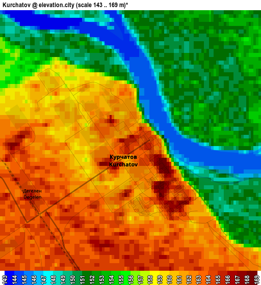
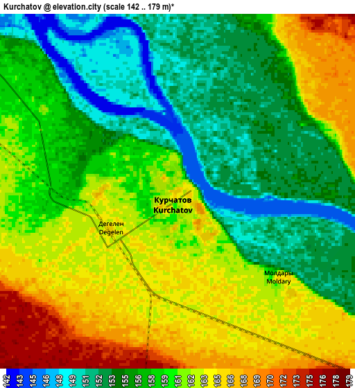
Below is the Elevation map of Kurchatov, which displays elevation range with different colors. Scale of the first map is from 143 to 169 m (469 to 554 ft) with average elevation of 156.5 meters (=513 ft) [note 1]
These maps also provides idea of topography and contour of this city, they are displayed at different zoom levels. More info about maps, scale and edge coordinates you can find below images.

| \ | Map #1 | Map #2 | Topo.Map |
| Scale [m] | 143..169 m | 142..179 m | × |
| Scale [ft] | 469..554 ft | 466..587 ft | × |
| Average | 156.5 m = 513 ft | 158.7 m = 521 ft | × |
| Width | 6.18 km = 3.8 mi | 12.36 km = 7.7 mi | 197.8 km = 122.9 mi |
| Height | 6.18 km = 3.8 mi | 12.36 km = 7.7 mi | 197.8 km = 122.9 mi |
| ↑Max Latitude | 50.783963° | 50.811739° | 51.63736° |
| Latitude at center | 50.75617° | 50.75617° | 50.75617° |
| ↓Min Latitude | 50.728361° | 50.700535° | 49.85807° |
| ← Min Longitude | 78.497935° | 78.453989° | 77.13563° |
| Longitude center | 78.54188° | 78.54188° | 78.54188° |
| →Max Longitude | 78.585825° | 78.629771° | 79.94813° |
Nearby cities:
Cities around Kurchatov sort by population:
• Pavlodar elevation 133 m
201.8 km,  327°
327°
• Semey 211 m
127.1 km,  106°
106°
• Aksu 123 m
181.4 km,  321°
321°
• Zhezkent 283 m
198.9 km,  84°
84°
• Leninskiy 109 m
206.3 km, 323°
• Mayqayyng 260 m
206.6 km,  292°
292°
• Borodulikha 316 m
168.1 km,  91°
91°
• Bayanaul 474 m
199.8 km,  271°
271°
• Kalkaman 122 m
219.6 km,  307°
307°
• Qaraūyl 622 m
207.8 km,  165°
165°
• Belogor’ye 131 m
113.9 km, 319°
• Suykbulak 363 m
213 km,  123°
123°
Multilingual:
 En español:
Kurchatov elevación 165 m.
 En France:
Kurchatov élévation 165 m.
 Auf Deutsch:
Kurchatov höhe über dem Meeresspiegel ist 165 m.

Sources and notes:
- [note 1] Map square and city borders are not equal. Map elevation data is calculated only from area inside that square.
- [src 1] Elevation data from geonames database provided with same terms of usage.
- [src 2] The elevation map of Kurchatov is generated using elevation data from NASA's 3 arcsec (90m) resolution SRTM data.
- [src 3] Base (background) map © OpenStreetMap contributors tiles are generated by Geofabrik and OpenTopoMap.
Copyright & License:
This Kurchatov Elevation Map is licensed under CC BY-SA. You may reuse any part from this page, if you give a proper credit by linking to this URL:
 More info on terms of use page.