Qaraūyl elevation
Qaraūyl (East Kazakhstan), Kazakhstan elevation is 622 meters and Qaraūyl elevation in feet is 2041 ft above sea level [src 1]. Qaraūyl is a populated place (feature code) with elevation that is 264 meters (866 ft) bigger than average city elevation in Kazakhstan.
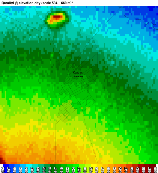
Below is the Elevation map of Qaraūyl, which displays elevation range with different colors. Scale of the first map is from 594 to 660 m (1949 to 2165 ft) with average elevation of 619.6 meters (=2033 ft) [note 1]
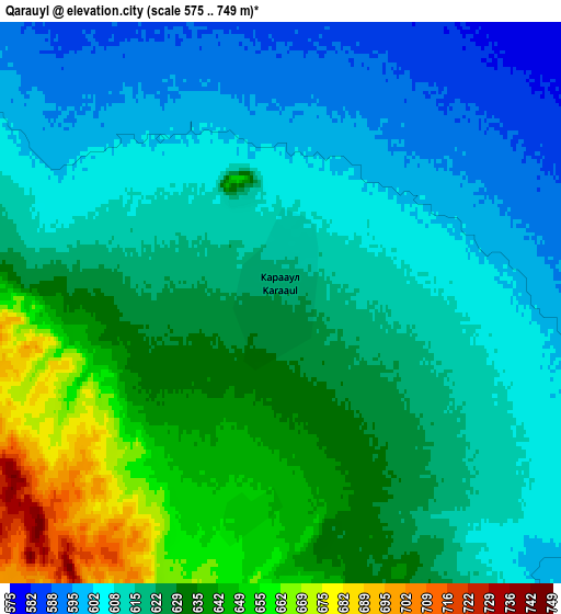
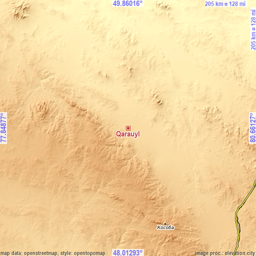
These maps also provides idea of topography and contour of this city, they are displayed at different zoom levels. More info about maps, scale and edge coordinates you can find below images.
| \ | Map #1 | Map #2 | Topo.Map |
| Scale [m] | 594..660 m | 575..749 m | × |
| Scale [ft] | 1949..2165 ft | 1886..2457 ft | × |
| Average | 619.6 m = 2033 ft | 621.1 m = 2038 ft | × |
| Width | 6.42 km = 4 mi | 12.84 km = 8 mi | 205.4 km = 127.6 mi |
| Height | 6.42 km = 4 mi | 12.84 km = 8 mi | 205.4 km = 127.6 mi |
| ↑Max Latitude | 48.973944° | 49.002782° | 49.86016° |
| Latitude at center | 48.94509° | 48.94509° | 48.94509° |
| ↓Min Latitude | 48.916219° | 48.887332° | 48.01293° |
| ← Min Longitude | 79.211075° | 79.167129° | 77.84877° |
| Longitude center | 79.25502° | 79.25502° | 79.25502° |
| →Max Longitude | 79.298965° | 79.342911° | 80.66127° |
Nearby cities:
Cities around Qaraūyl sort by population:
• Semey elevation 211 m
180.1 km,  23°
23°
• Ayagoz 665 m
139.5 km,  141°
141°
• Georgīevka 425 m
173.9 km,  75°
75°
• Kurchatov 165 m
207.8 km,  345°
345°
• Shar 339 m
148.4 km,  61°
61°
• Borodulikha 316 m
230.9 km,  31°
31°
• Aqtoghay 365 m
223.9 km,  172°
172°
• Zhalghyztobe 453 m
145.8 km, 78°
• Auezov 402 m
188.7 km, 63°
• Sarykamys 544 m
135.2 km,  197°
197°
• Suykbulak 363 m
155.2 km, 56°
• Priisk Boko 630 m
174.8 km,  85°
85°
Multilingual:
 En español:
Qaraūyl elevación 622 m.
 En France:
Qaraūyl élévation 622 m.


Sources and notes:
- [note 1] Map square and city borders are not equal. Map elevation data is calculated only from area inside that square.
- [src 1] Elevation data from geonames database provided with same terms of usage.
- [src 2] The elevation map of Qaraūyl is generated using elevation data from NASA's 3 arcsec (90m) resolution SRTM data.
- [src 3] Base (background) map © OpenStreetMap contributors tiles are generated by Geofabrik and OpenTopoMap.
Copyright & License:
This Qaraūyl Elevation Map is licensed under CC BY-SA. You may reuse any part from this page, if you give a proper credit by linking to this URL:
 More info on terms of use page.