Sarykamys elevation
Sarykamys, Kazakhstan elevation is 544 meters and Sarykamys elevation in feet is 1785 ft above sea level [src 1]. Sarykamys is a populated place (feature code) with elevation that is 186 meters (610 ft) bigger than average city elevation in Kazakhstan.
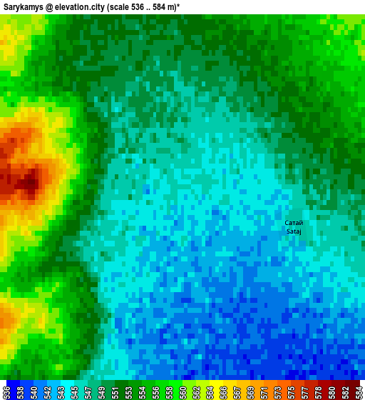
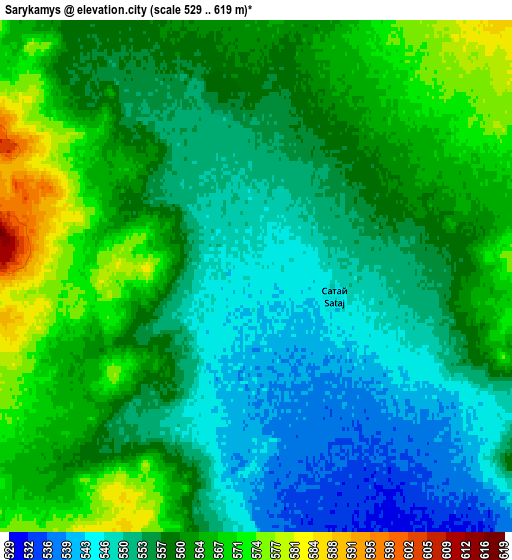
Below is the Elevation map of Sarykamys, which displays elevation range with different colors. Scale of the first map is from 536 to 584 m (1759 to 1916 ft) with average elevation of 549.7 meters (=1803 ft) [note 1]
These maps also provides idea of topography and contour of this city, they are displayed at different zoom levels. More info about maps, scale and edge coordinates you can find below images.
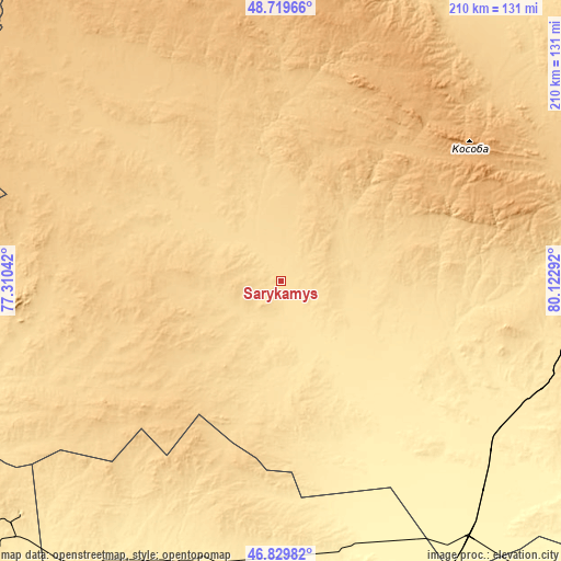
| \ | Map #1 | Map #2 | Topo.Map |
| Scale [m] | 536..584 m | 529..619 m | × |
| Scale [ft] | 1759..1916 ft | 1736..2031 ft | × |
| Average | 549.7 m = 1803 ft | 557.7 m = 1830 ft | × |
| Width | 6.57 km = 4.1 mi | 13.13 km = 8.2 mi | 210.1 km = 130.5 mi |
| Height | 6.57 km = 4.1 mi | 13.13 km = 8.2 mi | 210.1 km = 130.5 mi |
| ↑Max Latitude | 47.81285° | 47.842353° | 48.71966° |
| Latitude at center | 47.78333° | 47.78333° | 47.78333° |
| ↓Min Latitude | 47.753793° | 47.72424° | 46.82982° |
| ← Min Longitude | 78.672725° | 78.628779° | 77.31042° |
| Longitude center | 78.71667° | 78.71667° | 78.71667° |
| →Max Longitude | 78.760615° | 78.804561° | 80.12292° |
Nearby cities:
Cities around Sarykamys sort by population:
• Ayagoz elevation 665 m
129.7 km,  81°
81°
• Urzhar 479 m
232.1 km,  109°
109°
• Shar 339 m
263.7 km,  40°
40°
• Lepsy 401 m
173 km,  174°
174°
• Qaraūyl 622 m
135.2 km,  17°
17°
• Aqtoghay 365 m
117.1 km,  142°
142°
• Sayaq 593 m
139.6 km,  231°
231°
• Zhalghyztobe 453 m
243.1 km,  49°
49°
• Matay 412 m
210 km,  179°
179°
• Aktogay 753 m
257.8 km,  279°
279°
• Karabas 340 m
235.6 km, 233°
• Priisk Boko 630 m
258.5 km,  56°
56°
Multilingual:
 En español:
Sarykamys elevación 544 m.
 En France:
Sarykamys élévation 544 m.
 Auf Deutsch:
Sarykamys höhe über dem Meeresspiegel ist 544 m.

Sources and notes:
- [note 1] Map square and city borders are not equal. Map elevation data is calculated only from area inside that square.
- [src 1] Elevation data from geonames database provided with same terms of usage.
- [src 2] The elevation map of Sarykamys is generated using elevation data from NASA's 3 arcsec (90m) resolution SRTM data.
- [src 3] Base (background) map © OpenStreetMap contributors tiles are generated by Geofabrik and OpenTopoMap.
Copyright & License:
This Sarykamys Elevation Map is licensed under CC BY-SA. You may reuse any part from this page, if you give a proper credit by linking to this URL:
 More info on terms of use page.