Urzhar elevation
Urzhar (East Kazakhstan), Kazakhstan elevation is 479 meters and Urzhar elevation in feet is 1572 ft above sea level [src 1]. Urzhar is a populated place (feature code) with elevation that is 121 meters (397 ft) bigger than average city elevation in Kazakhstan.
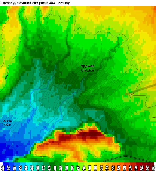
Below is the Elevation map of Urzhar, which displays elevation range with different colors. Scale of the first map is from 443 to 551 m (1453 to 1808 ft) with average elevation of 489.7 meters (=1607 ft) [note 1]
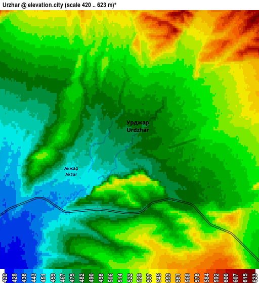
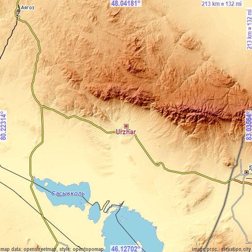
These maps also provides idea of topography and contour of this city, they are displayed at different zoom levels. More info about maps, scale and edge coordinates you can find below images.
| \ | Map #1 | Map #2 | Topo.Map |
| Scale [m] | 443..551 m | 420..623 m | × |
| Scale [ft] | 1453..1808 ft | 1378..2044 ft | × |
| Average | 489.7 m = 1607 ft | 504.5 m = 1655 ft | × |
| Width | 6.65 km = 4.1 mi | 13.31 km = 8.3 mi | 212.9 km = 132.3 mi |
| Height | 6.65 km = 4.1 mi | 13.31 km = 8.3 mi | 212.9 km = 132.3 mi |
| ↑Max Latitude | 47.12293° | 47.152823° | 48.04181° |
| Latitude at center | 47.09302° | 47.09302° | 47.09302° |
| ↓Min Latitude | 47.063093° | 47.03315° | 46.12702° |
| ← Min Longitude | 81.585445° | 81.541499° | 80.22314° |
| Longitude center | 81.62939° | 81.62939° | 81.62939° |
| →Max Longitude | 81.673335° | 81.717281° | 83.03564° |
Nearby cities:
Cities around Urzhar sort by population:
• Sarkand elevation 772 m
228.7 km,  215°
215°
• Ayagoz 665 m
132.1 km,  317°
317°
• Kurchum 427 m
223.2 km,  42°
42°
• Aksuat 534 m
237.5 km, 40°
• Tūghyl 404 m
206.2 km,  70°
70°
• Lepsy 401 m
225.9 km,  245°
245°
• Kokpekty 514 m
193 km,  17°
17°
• Aqtoghay 365 m
149.6 km,  263°
263°
• Zhalghyztobe 453 m
237.5 km,  352°
352°
• Sarykamys 544 m
232.1 km,  289°
289°
• Druzhba 424 m
214.8 km,  162°
162°
• Priisk Boko 630 m
218.7 km,  0°
0°
Multilingual:
 En español:
Urzhar elevación 479 m.
 En France:
Urzhar élévation 479 m.


Sources and notes:
- [note 1] Map square and city borders are not equal. Map elevation data is calculated only from area inside that square.
- [src 1] Elevation data from geonames database provided with same terms of usage.
- [src 2] The elevation map of Urzhar is generated using elevation data from NASA's 3 arcsec (90m) resolution SRTM data.
- [src 3] Base (background) map © OpenStreetMap contributors tiles are generated by Geofabrik and OpenTopoMap.
Copyright & License:
This Urzhar Elevation Map is licensed under CC BY-SA. You may reuse any part from this page, if you give a proper credit by linking to this URL:
 More info on terms of use page.