Irtyshsk elevation
Irtyshsk (Pavlodar Region), Kazakhstan elevation is 91 meters and Irtyshsk elevation in feet is 299 ft above sea level [src 1]. Irtyshsk is a populated place (feature code) with elevation that is 267 meters (876 ft) smaller than average city elevation in Kazakhstan.
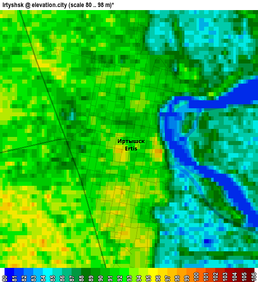
Below is the Elevation map of Irtyshsk, which displays elevation range with different colors. Scale of the first map is from 80 to 98 m (262 to 322 ft) with average elevation of 89.5 meters (=294 ft) [note 1]
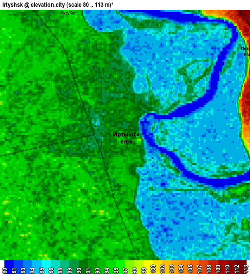
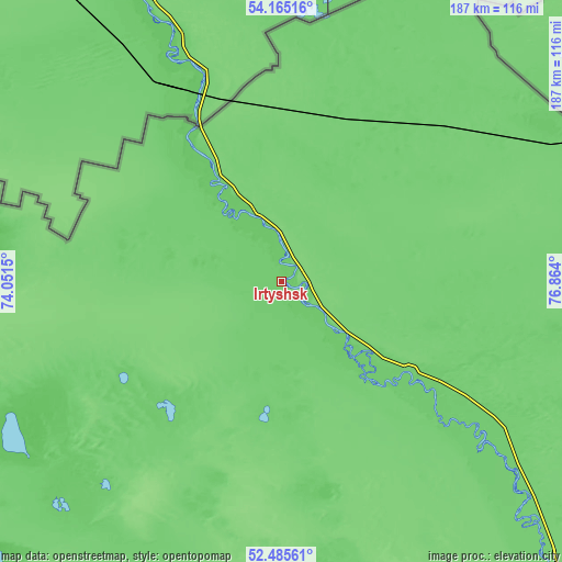
These maps also provides idea of topography and contour of this city, they are displayed at different zoom levels. More info about maps, scale and edge coordinates you can find below images.
| \ | Map #1 | Map #2 | Topo.Map |
| Scale [m] | 80..98 m | 80..113 m | × |
| Scale [ft] | 262..322 ft | 262..371 ft | × |
| Average | 89.5 m = 294 ft | 89.8 m = 295 ft | × |
| Width | 5.84 km = 3.6 mi | 11.67 km = 7.3 mi | 186.7 km = 116 mi |
| Height | 5.84 km = 3.6 mi | 11.67 km = 7.3 mi | 186.7 km = 116 mi |
| ↑Max Latitude | 53.359884° | 53.386102° | 54.16516° |
| Latitude at center | 53.33365° | 53.33365° | 53.33365° |
| ↓Min Latitude | 53.3074° | 53.281133° | 52.48561° |
| ← Min Longitude | 75.413805° | 75.369859° | 74.0515° |
| Longitude center | 75.45775° | 75.45775° | 75.45775° |
| →Max Longitude | 75.501695° | 75.545641° | 76.864° |
Nearby cities:
Cities around Irtyshsk sort by population:
• Pavlodar elevation 133 m
154.7 km,  139°
139°
• Ekibastuz 203 m
179.2 km,  182°
182°
• Aksu 123 m
174.6 km,  145°
145°
• Qashyr 97 m
52.3 km,  124°
124°
• Leninskiy 109 m
149.5 km, 143°
• Mayqayyng 260 m
209.7 km,  173°
173°
• Bestobe 174 m
183.6 km,  239°
239°
• Kzyltu 135 m
208.9 km,  279°
279°
• Kalkaman 122 m
158.2 km, 165°
• Zhelezinka 92 m
24.7 km,  337°
337°
• Belogor’ye 131 m
242.6 km, 145°
• Talshik 75 m
239.5 km, 278°
Multilingual:
 En español:
Irtyshsk elevación 91 m.
 En France:
Irtyshsk élévation 91 m.


Sources and notes:
- [note 1] Map square and city borders are not equal. Map elevation data is calculated only from area inside that square.
- [src 1] Elevation data from geonames database provided with same terms of usage.
- [src 2] The elevation map of Irtyshsk is generated using elevation data from NASA's 3 arcsec (90m) resolution SRTM data.
- [src 3] Base (background) map © OpenStreetMap contributors tiles are generated by Geofabrik and OpenTopoMap.
Copyright & License:
This Irtyshsk Elevation Map is licensed under CC BY-SA. You may reuse any part from this page, if you give a proper credit by linking to this URL:
 More info on terms of use page.