Colubro elevation
Colubro (Latium, Città metropolitana di Roma Capitale), Italy elevation is 299 meters and Colubro elevation in feet is 981 ft above sea level [src 1]. Colubro is a populated place (feature code) with elevation that is 23 meters (75 ft) smaller than average city elevation in Italy.
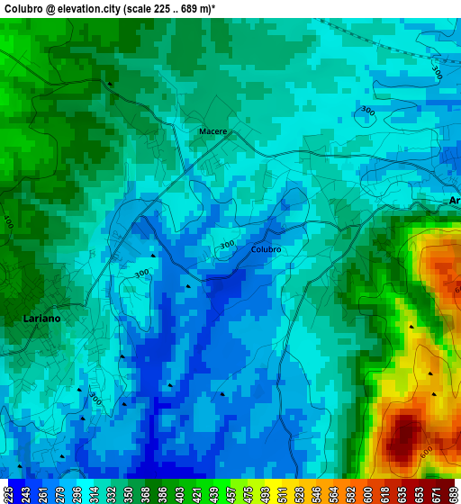
Below is the Elevation map of Colubro, which displays elevation range with different colors. Scale of the first map is from 225 to 689 m (738 to 2260 ft) with average elevation of 338.5 meters (=1111 ft) [note 1]
These maps also provides idea of topography and contour of this city, they are displayed at different zoom levels. More info about maps, scale and edge coordinates you can find below images.
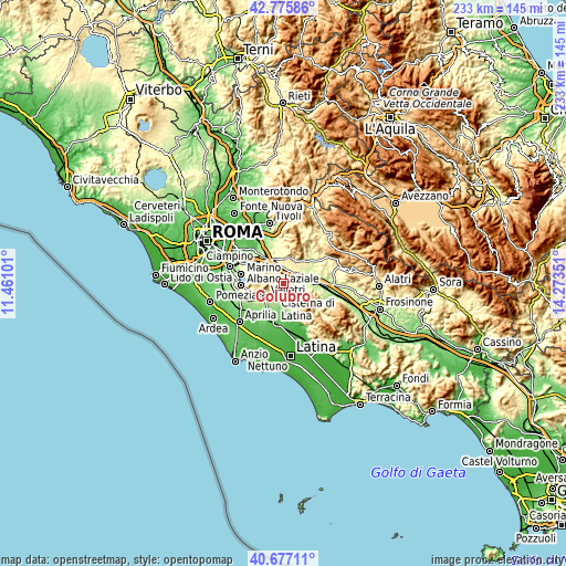
| \ | Map #1 | Topo.Map |
| Scale [m] | 225..689 m | × |
| Scale [ft] | 738..2260 ft | × |
| Average | 338.5 m = 1111 ft | × |
| Width | 7.29 km = 4.5 mi | 233.4 km = 145 mi |
| Height | 7.29 km = 4.5 mi | 233.4 km = 145 mi |
| ↑Max Latitude | 41.767845° | 42.77586° |
| Latitude at center | 41.73506° | 41.73506° |
| ↓Min Latitude | 41.702258° | 40.67711° |
| ← Min Longitude | 12.823315° | 11.46101° |
| Longitude center | 12.86726° | 12.86726° |
| →Max Longitude | 12.911205° | 14.27351° |
Nearby cities:
Cities around Colubro sort by population:
• Velletri elevation 359 m
9.2 km,  233°
233°
• Valmontone 267 m
6 km,  45°
45°
• Lariano 338 m
3.7 km,  240°
240°
• Artena 297 m
3.3 km,  78°
78°
• Rocca Priora 607 m
9.1 km,  292°
292°
• Labico 358 m
6.4 km,  2°
2°
• Giulianello 233 m
5.5 km,  169°
169°
• Carchitti 385 m
6.6 km,  331°
331°
• Colle di Fuori 389 m
8.9 km, 325°
• Macere 309 m
1.7 km, 334°
• Colle Spina 370 m
5.5 km,  342°
342°
• Rocca Massima 715 m
7.7 km,  144°
144°
Multilingual:
 En español:
Colubro elevación 299 m.
 En France:
Colubro élévation 299 m.


Sources and notes:
- [note 1] Map square and city borders are not equal. Map elevation data is calculated only from area inside that square.
- [src 1] Elevation data from geonames database provided with same terms of usage.
- [src 2] The elevation map of Colubro is generated using elevation data from NASA's 3 arcsec (90m) resolution SRTM data.
- [src 3] Base (background) map © OpenStreetMap contributors tiles are generated by Geofabrik and OpenTopoMap.
Copyright & License:
This Colubro Elevation Map is licensed under CC BY-SA. You may reuse any part from this page, if you give a proper credit by linking to this URL:
 More info on terms of use page.