Colle di Fuori elevation
Colle di Fuori (Latium, Città metropolitana di Roma Capitale), Italy elevation is 389 meters and Colle di Fuori elevation in feet is 1276 ft above sea level [src 1]. Colle di Fuori is a populated place (feature code) with elevation that is 67 meters (220 ft) bigger than average city elevation in Italy.
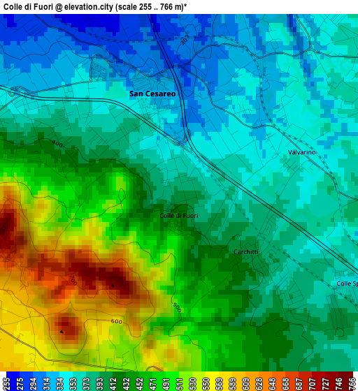
Below is the Elevation map of Colle di Fuori, which displays elevation range with different colors. Scale of the first map is from 255 to 766 m (837 to 2513 ft) with average elevation of 418.5 meters (=1373 ft) [note 1]
These maps also provides idea of topography and contour of this city, they are displayed at different zoom levels. More info about maps, scale and edge coordinates you can find below images.
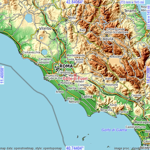
| \ | Map #1 | Topo.Map |
| Scale [m] | 255..766 m | × |
| Scale [ft] | 837..2513 ft | × |
| Average | 418.5 m = 1373 ft | × |
| Width | 7.29 km = 4.5 mi | 233.1 km = 144.8 mi |
| Height | 7.29 km = 4.5 mi | 233.1 km = 144.8 mi |
| ↑Max Latitude | 41.833661° | 42.84064° |
| Latitude at center | 41.80091° | 41.80091° |
| ↓Min Latitude | 41.768142° | 40.74404° |
| ← Min Longitude | 12.762885° | 11.40058° |
| Longitude center | 12.80683° | 12.80683° |
| →Max Longitude | 12.850775° | 14.21308° |
Nearby cities:
Cities around Colle di Fuori sort by population:
• Palestrina elevation 410 m
7.1 km,  60°
60°
• Zagarolo 288 m
4.6 km,  8°
8°
• San Cesareo 318 m
2.3 km,  355°
355°
• Rocca Priora 607 m
5.2 km,  221°
221°
• Monte Porzio Catone 442 m
7.8 km,  282°
282°
• Montecompatri 573 m
5.8 km, 278°
• Labico 358 m
5.4 km,  99°
99°
• Gallicano nel Lazio 304 m
7.4 km,  18°
18°
• Colonna 293 m
5.7 km,  311°
311°
• Carchitti 385 m
2.4 km,  129°
129°
• Macere 309 m
7.2 km,  143°
143°
• Colle Spina 370 m
4 km,  122°
122°
Multilingual:
 En español:
Colle di Fuori elevación 389 m.
 En France:
Colle di Fuori élévation 389 m.
 Auf Deutsch:
Colle di Fuori höhe über dem Meeresspiegel ist 389 m.

Sources and notes:
- [note 1] Map square and city borders are not equal. Map elevation data is calculated only from area inside that square.
- [src 1] Elevation data from geonames database provided with same terms of usage.
- [src 2] The elevation map of Colle di Fuori is generated using elevation data from NASA's 3 arcsec (90m) resolution SRTM data.
- [src 3] Base (background) map © OpenStreetMap contributors tiles are generated by Geofabrik and OpenTopoMap.
Copyright & License:
This Colle di Fuori Elevation Map is licensed under CC BY-SA. You may reuse any part from this page, if you give a proper credit by linking to this URL:
 More info on terms of use page.