Sant'Albino elevation
Sant'Albino (Tuscany, Provincia di Siena), Italy elevation is 485 meters and Sant'Albino elevation in feet is 1591 ft above sea level [src 1]. Sant'Albino is a populated place (feature code) with elevation that is 163 meters (535 ft) bigger than average city elevation in Italy.
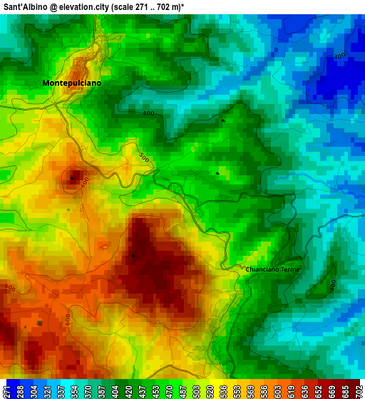
Below is the Elevation map of Sant'Albino, which displays elevation range with different colors. Scale of the first map is from 271 to 702 m (889 to 2303 ft) with average elevation of 464.6 meters (=1524 ft) [note 1]
These maps also provides idea of topography and contour of this city, they are displayed at different zoom levels. More info about maps, scale and edge coordinates you can find below images.
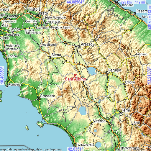
| \ | Map #1 | Topo.Map |
| Scale [m] | 271..702 m | × |
| Scale [ft] | 889..2303 ft | × |
| Average | 464.6 m = 1524 ft | × |
| Width | 7.14 km = 4.4 mi | 228.4 km = 141.9 mi |
| Height | 7.14 km = 4.4 mi | 228.4 km = 141.9 mi |
| ↑Max Latitude | 43.103074° | 44.08964° |
| Latitude at center | 43.07098° | 43.07098° |
| ↓Min Latitude | 43.038869° | 42.0351° |
| ← Min Longitude | 11.762895° | 10.40059° |
| Longitude center | 11.80684° | 11.80684° |
| →Max Longitude | 11.850785° | 13.21309° |
Nearby cities:
Cities around Sant'Albino sort by population:
• Chianciano Terme elevation 515 m
3.3 km,  172°
172°
• Torrita di Siena 263 m
11.4 km,  350°
350°
• Chiusi Scalo 266 m
14.6 km,  124°
124°
• Sarteano 531 m
10 km,  151°
151°
• Montepulciano 492 m
3.6 km,  333°
333°
• Bettolle 297 m
15.1 km,  359°
359°
• Chiusi 344 m
13.1 km, 118°
• Montepulciano Stazione 260 m
8.2 km,  28°
28°
• Acquaviva 292 m
6.7 km,  42°
42°
• Cetona 329 m
14 km, 146°
• Pienza 490 m
10.6 km,  274°
274°
• Pozzuolo 357 m
13.4 km,  65°
65°
Multilingual:
 En español:
Sant'Albino elevación 485 m.
 En France:
Sant'Albino élévation 485 m.
 Auf Deutsch:
Sant'Albino höhe über dem Meeresspiegel ist 485 m.

Sources and notes:
- [note 1] Map square and city borders are not equal. Map elevation data is calculated only from area inside that square.
- [src 1] Elevation data from geonames database provided with same terms of usage.
- [src 2] The elevation map of Sant'Albino is generated using elevation data from NASA's 3 arcsec (90m) resolution SRTM data.
- [src 3] Base (background) map © OpenStreetMap contributors tiles are generated by Geofabrik and OpenTopoMap.
Copyright & License:
This Sant'Albino Elevation Map is licensed under CC BY-SA. You may reuse any part from this page, if you give a proper credit by linking to this URL:
 More info on terms of use page.