Pozzuolo elevation
Pozzuolo (Umbria, Provincia di Perugia), Italy elevation is 357 meters and Pozzuolo elevation in feet is 1171 ft above sea level [src 1]. Pozzuolo is a populated place (feature code) with elevation that is 35 meters (115 ft) bigger than average city elevation in Italy.
Below is the Elevation map of Pozzuolo, which displays elevation range with different colors. Scale of the first map is from 244 to 368 m (801 to 1207 ft) with average elevation of 298.1 meters (=978 ft) [note 1]
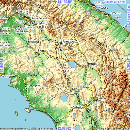
These maps also provides idea of topography and contour of this city, they are displayed at different zoom levels. More info about maps, scale and edge coordinates you can find below images.
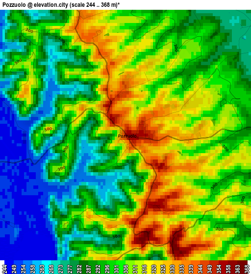
| \ | Map #1 | Topo.Map |
| Scale [m] | 244..368 m | × |
| Scale [ft] | 801..1207 ft | × |
| Average | 298.1 m = 978 ft | × |
| Width | 7.13 km = 4.4 mi | 228.3 km = 141.9 mi |
| Height | 7.13 km = 4.4 mi | 228.2 km = 141.8 mi |
| ↑Max Latitude | 43.153717° | 44.13946° |
| Latitude at center | 43.12165° | 43.12165° |
| ↓Min Latitude | 43.089566° | 42.08662° |
| ← Min Longitude | 11.912045° | 10.54974° |
| Longitude center | 11.95599° | 11.95599° |
| →Max Longitude | 11.999935° | 13.36224° |
Nearby cities:
Cities around Pozzuolo sort by population:
• Chianciano Terme elevation 515 m
14.7 km,  232°
232°
• Torrita di Siena 263 m
15.1 km,  292°
292°
• Castiglione del Lago 264 m
6.8 km,  87°
87°
• Chiusi Scalo 266 m
14 km,  180°
180°
• Montepulciano 492 m
13.9 km,  260°
260°
• Tuoro sul Trasimeno 272 m
13.5 km,  45°
45°
• Chiusi 344 m
12 km, 183°
• Terontola 274 m
10.8 km,  24°
24°
• Montepulciano Stazione 260 m
8.3 km,  280°
280°
• Acquaviva 292 m
7.6 km, 264°
• Sant'Albino 485 m
13.4 km,  245°
245°
• Paciano 364 m
14.3 km,  140°
140°
Multilingual:
 En español:
Pozzuolo elevación 357 m.
 En France:
Pozzuolo élévation 357 m.
 Auf Deutsch:
Pozzuolo höhe über dem Meeresspiegel ist 357 m.

Sources and notes:
- [note 1] Map square and city borders are not equal. Map elevation data is calculated only from area inside that square.
- [src 1] Elevation data from geonames database provided with same terms of usage.
- [src 2] The elevation map of Pozzuolo is generated using elevation data from NASA's 3 arcsec (90m) resolution SRTM data.
- [src 3] Base (background) map © OpenStreetMap contributors tiles are generated by Geofabrik and OpenTopoMap.
Copyright & License:
This Pozzuolo Elevation Map is licensed under CC BY-SA. You may reuse any part from this page, if you give a proper credit by linking to this URL:
 More info on terms of use page.