Pienza elevation
Pienza (Tuscany, Provincia di Siena), Italy elevation is 490 meters and Pienza elevation in feet is 1608 ft above sea level [src 1]. Pienza is a seat of a third-order administrative division (feature code) with elevation that is 168 meters (551 ft) bigger than average city elevation in Italy.
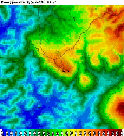
Below is the Elevation map of Pienza, which displays elevation range with different colors. Scale of the first map is from 278 to 545 m (912 to 1788 ft) with average elevation of 372.8 meters (=1223 ft) [note 1]
These maps also provides idea of topography and contour of this city, they are displayed at different zoom levels. More info about maps, scale and edge coordinates you can find below images.

| \ | Map #1 | Topo.Map |
| Scale [m] | 278..545 m | × |
| Scale [ft] | 912..1788 ft | × |
| Average | 372.8 m = 1223 ft | × |
| Width | 7.14 km = 4.4 mi | 228.4 km = 141.9 mi |
| Height | 7.14 km = 4.4 mi | 228.4 km = 141.9 mi |
| ↑Max Latitude | 43.11082° | 44.09726° |
| Latitude at center | 43.07873° | 43.07873° |
| ↓Min Latitude | 43.046623° | 42.04298° |
| ← Min Longitude | 11.632765° | 10.27046° |
| Longitude center | 11.67671° | 11.67671° |
| →Max Longitude | 11.720655° | 13.08296° |
Nearby cities:
Cities around Pienza sort by population:
• Chianciano Terme elevation 515 m
11.7 km,  110°
110°
• Torrita di Siena 263 m
13.6 km,  39°
39°
• Montepulciano 492 m
9.3 km,  75°
75°
• San Quirico d'Orcia 419 m
6.3 km,  248°
248°
• Montalcino 565 m
15.5 km,  259°
259°
• Montepulciano Stazione 260 m
15.8 km,  66°
66°
• Torrenieri 256 m
10.4 km,  274°
274°
• Acquaviva 292 m
15.6 km, 74°
• Sant'Albino 485 m
10.6 km,  94°
94°
• Castiglione d'Orcia 534 m
9.7 km,  211°
211°
• Trequanda 434 m
12.1 km,  356°
356°
• San Giovanni d'Asso 306 m
10.9 km,  319°
319°
Multilingual:
 En español:
Pienza elevación 490 m.
 En France:
Pienza élévation 490 m.


Sources and notes:
- [note 1] Map square and city borders are not equal. Map elevation data is calculated only from area inside that square.
- [src 1] Elevation data from geonames database provided with same terms of usage.
- [src 2] The elevation map of Pienza is generated using elevation data from NASA's 3 arcsec (90m) resolution SRTM data.
- [src 3] Base (background) map © OpenStreetMap contributors tiles are generated by Geofabrik and OpenTopoMap.
Copyright & License:
This Pienza Elevation Map is licensed under CC BY-SA. You may reuse any part from this page, if you give a proper credit by linking to this URL:
 More info on terms of use page.