Abbazia elevation
Abbazia (Lombardy, Provincia di Bergamo), Italy elevation is 418 meters and Abbazia elevation in feet is 1371 ft above sea level [src 1]. Abbazia is a populated place (feature code) with elevation that is 96 meters (315 ft) bigger than average city elevation in Italy.
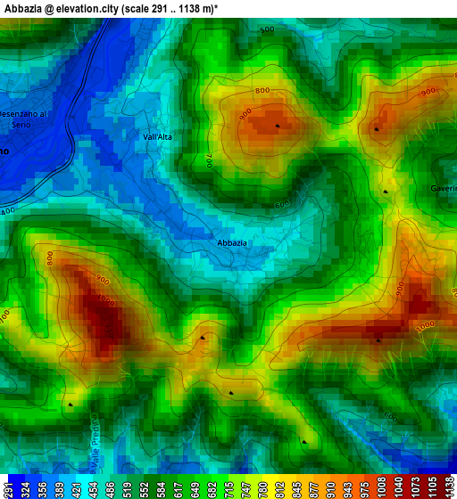
Below is the Elevation map of Abbazia, which displays elevation range with different colors. Scale of the first map is from 291 to 1138 m (955 to 3734 ft) with average elevation of 619.6 meters (=2033 ft) [note 1]
These maps also provides idea of topography and contour of this city, they are displayed at different zoom levels. More info about maps, scale and edge coordinates you can find below images.
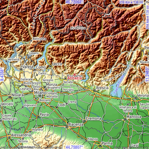
| \ | Map #1 | Topo.Map |
| Scale [m] | 291..1138 m | × |
| Scale [ft] | 955..3734 ft | × |
| Average | 619.6 m = 2033 ft | × |
| Width | 6.82 km = 4.2 mi | 218.2 km = 135.6 mi |
| Height | 6.82 km = 4.2 mi | 218.2 km = 135.6 mi |
| ↑Max Latitude | 45.778657° | 46.72068° |
| Latitude at center | 45.748° | 45.748° |
| ↓Min Latitude | 45.717326° | 44.75807° |
| ← Min Longitude | 9.798105° | 8.4358° |
| Longitude center | 9.84205° | 9.84205° |
| →Max Longitude | 9.885995° | 11.2483° |
Nearby cities:
Cities around Abbazia sort by population:
• Albino elevation 375 m
3.8 km,  298°
298°
• Pradalunga 318 m
4.6 km,  267°
267°
• Casazza 339 m
5 km,  89°
89°
• Cene 370 m
3.8 km,  341°
341°
• Cenate Sopra 343 m
4.2 km,  201°
201°
• Casco 322 m
4.3 km, 197°
• Entratico 273 m
5.1 km,  151°
151°
• Vall'Alta 414 m
1.9 km,  320°
320°
• Borgo di Terzo 301 m
4.9 km,  128°
128°
• Vigano San Martino 335 m
4.9 km,  120°
120°
• Luzzana 295 m
4.7 km,  140°
140°
• Gaverina Terme 494 m
3.6 km,  75°
75°
Multilingual:
 En español:
Abbazia elevación 418 m.
 En France:
Abbazia élévation 418 m.


Sources and notes:
- [note 1] Map square and city borders are not equal. Map elevation data is calculated only from area inside that square.
- [src 1] Elevation data from geonames database provided with same terms of usage.
- [src 2] The elevation map of Abbazia is generated using elevation data from NASA's 3 arcsec (90m) resolution SRTM data.
- [src 3] Base (background) map © OpenStreetMap contributors tiles are generated by Geofabrik and OpenTopoMap.
Copyright & License:
This Abbazia Elevation Map is licensed under CC BY-SA. You may reuse any part from this page, if you give a proper credit by linking to this URL:
 More info on terms of use page.