Entratico elevation
Entratico (Lombardy, Provincia di Bergamo), Italy elevation is 273 meters and Entratico elevation in feet is 896 ft above sea level [src 1]. Entratico is a seat of a third-order administrative division (feature code) with elevation that is 49 meters (161 ft) smaller than average city elevation in Italy.
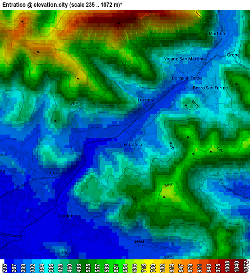
Below is the Elevation map of Entratico, which displays elevation range with different colors. Scale of the first map is from 235 to 1072 m (771 to 3517 ft) with average elevation of 444 meters (=1457 ft) [note 1]
These maps also provides idea of topography and contour of this city, they are displayed at different zoom levels. More info about maps, scale and edge coordinates you can find below images.
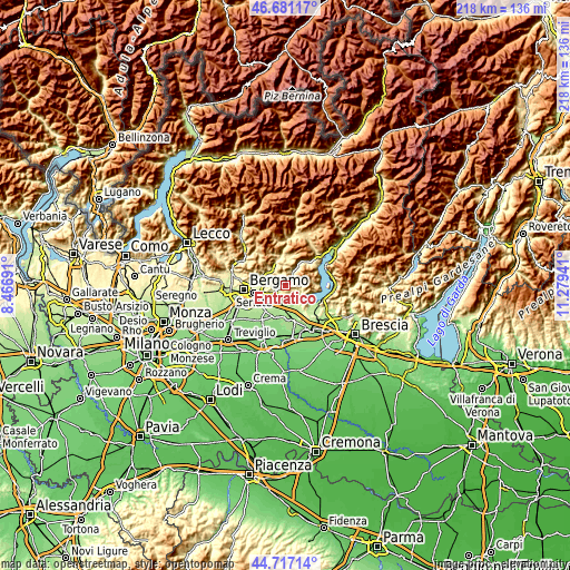
| \ | Map #1 | Topo.Map |
| Scale [m] | 235..1072 m | × |
| Scale [ft] | 771..3517 ft | × |
| Average | 444 m = 1457 ft | × |
| Width | 6.82 km = 4.2 mi | 218.4 km = 135.7 mi |
| Height | 6.82 km = 4.2 mi | 218.4 km = 135.7 mi |
| ↑Max Latitude | 45.738459° | 46.68117° |
| Latitude at center | 45.70778° | 45.70778° |
| ↓Min Latitude | 45.677084° | 44.71714° |
| ← Min Longitude | 9.829215° | 8.46691° |
| Longitude center | 9.87316° | 9.87316° |
| →Max Longitude | 9.917105° | 11.27941° |
Nearby cities:
Cities around Entratico sort by population:
• Trescore Balneario elevation 271 m
2.9 km,  238°
238°
• Chiesa 347 m
3.7 km,  122°
122°
• Foresto Sparso 262 m
4.1 km, 117°
• Cenate di Sotto 268 m
3.8 km,  254°
254°
• Zandobbio 266 m
2.7 km,  206°
206°
• Cenate Sopra 343 m
4 km,  278°
278°
• Casco 322 m
3.8 km, 275°
• Berzo San Fermo 341 m
2.7 km,  61°
61°
• Borgo di Terzo 301 m
2 km,  43°
43°
• Vigano San Martino 335 m
2.7 km, 41°
• Luzzana 295 m
1 km, 36°
• Grone 353 m
3.5 km,  52°
52°
Multilingual:
 En español:
Entratico elevación 273 m.
 En France:
Entratico élévation 273 m.
 Auf Deutsch:
Entratico höhe über dem Meeresspiegel ist 273 m.

Sources and notes:
- [note 1] Map square and city borders are not equal. Map elevation data is calculated only from area inside that square.
- [src 1] Elevation data from geonames database provided with same terms of usage.
- [src 2] The elevation map of Entratico is generated using elevation data from NASA's 3 arcsec (90m) resolution SRTM data.
- [src 3] Base (background) map © OpenStreetMap contributors tiles are generated by Geofabrik and OpenTopoMap.
Copyright & License:
This Entratico Elevation Map is licensed under CC BY-SA. You may reuse any part from this page, if you give a proper credit by linking to this URL:
 More info on terms of use page.