Grone elevation
Grone (Lombardy, Provincia di Bergamo), Italy elevation is 353 meters and Grone elevation in feet is 1158 ft above sea level [src 1]. Grone is a seat of a third-order administrative division (feature code) with elevation that is 31 meters (102 ft) bigger than average city elevation in Italy.
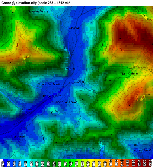
Below is the Elevation map of Grone, which displays elevation range with different colors. Scale of the first map is from 263 to 1312 m (863 to 4304 ft) with average elevation of 610.5 meters (=2003 ft) [note 1]
These maps also provides idea of topography and contour of this city, they are displayed at different zoom levels. More info about maps, scale and edge coordinates you can find below images.
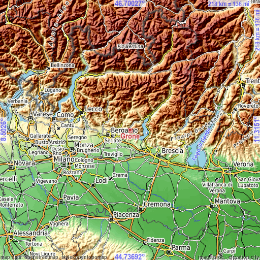
| \ | Map #1 | Topo.Map |
| Scale [m] | 263..1312 m | × |
| Scale [ft] | 863..4304 ft | × |
| Average | 610.5 m = 2003 ft | × |
| Width | 6.82 km = 4.2 mi | 218.3 km = 135.6 mi |
| Height | 6.82 km = 4.2 mi | 218.3 km = 135.6 mi |
| ↑Max Latitude | 45.757889° | 46.70027° |
| Latitude at center | 45.72722° | 45.72722° |
| ↓Min Latitude | 45.696534° | 44.73692° |
| ← Min Longitude | 9.864905° | 8.5026° |
| Longitude center | 9.90885° | 9.90885° |
| →Max Longitude | 9.952795° | 11.3151° |
Nearby cities:
Cities around Grone sort by population:
• Casazza elevation 339 m
2.4 km,  355°
355°
• Chiesa 347 m
4.1 km,  175°
175°
• Foresto Sparso 262 m
4.1 km,  167°
167°
• Entratico 273 m
3.5 km,  232°
232°
• Adrara San Martino 402 m
4.2 km,  131°
131°
• Berzo San Fermo 341 m
1 km,  206°
206°
• Borgo di Terzo 301 m
1.6 km,  242°
242°
• Vigano San Martino 335 m
1 km,  262°
262°
• Spinone al Lago 353 m
4.3 km,  13°
13°
• Adrara San Rocco 432 m
4.1 km,  108°
108°
• Luzzana 295 m
2.5 km, 238°
• Gaverina Terme 494 m
3.6 km,  331°
331°
Multilingual:
 En español:
Grone elevación 353 m.
 En France:
Grone élévation 353 m.


Sources and notes:
- [note 1] Map square and city borders are not equal. Map elevation data is calculated only from area inside that square.
- [src 1] Elevation data from geonames database provided with same terms of usage.
- [src 2] The elevation map of Grone is generated using elevation data from NASA's 3 arcsec (90m) resolution SRTM data.
- [src 3] Base (background) map © OpenStreetMap contributors tiles are generated by Geofabrik and OpenTopoMap.
Copyright & License:
This Grone Elevation Map is licensed under CC BY-SA. You may reuse any part from this page, if you give a proper credit by linking to this URL:
 More info on terms of use page.