Casco elevation
Casco (Lombardy, Provincia di Bergamo), Italy elevation is 322 meters and Casco elevation in feet is 1056 ft above sea level [src 1]. Casco is a seat of a third-order administrative division (feature code) with elevation that is 0 meters (0 ft) bigger than average city elevation in Italy.
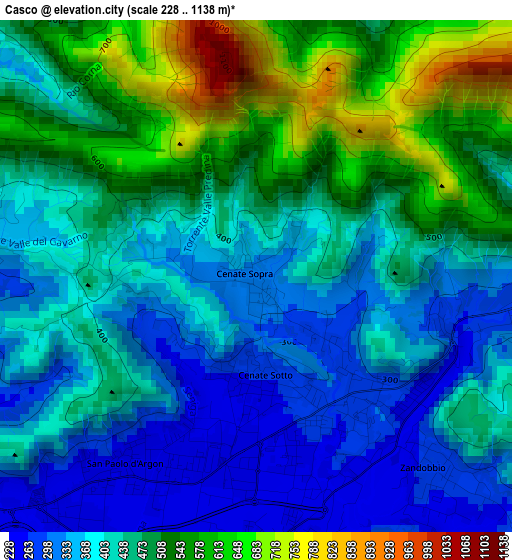
Below is the Elevation map of Casco, which displays elevation range with different colors. Scale of the first map is from 228 to 1138 m (748 to 3734 ft) with average elevation of 441.5 meters (=1448 ft) [note 1]
These maps also provides idea of topography and contour of this city, they are displayed at different zoom levels. More info about maps, scale and edge coordinates you can find below images.
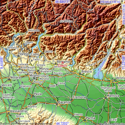
| \ | Map #1 | Topo.Map |
| Scale [m] | 228..1138 m | × |
| Scale [ft] | 748..3734 ft | × |
| Average | 441.5 m = 1448 ft | × |
| Width | 6.82 km = 4.2 mi | 218.4 km = 135.7 mi |
| Height | 6.82 km = 4.2 mi | 218.4 km = 135.7 mi |
| ↑Max Latitude | 45.741458° | 46.68411° |
| Latitude at center | 45.71078° | 45.71078° |
| ↓Min Latitude | 45.680085° | 44.7202° |
| ← Min Longitude | 9.780885° | 8.41858° |
| Longitude center | 9.82483° | 9.82483° |
| →Max Longitude | 9.868775° | 11.23108° |
Nearby cities:
Cities around Casco sort by population:
• Trescore Balneario elevation 271 m
2.3 km,  144°
144°
• Gorlago 236 m
4.1 km,  182°
182°
• San Paolo d'Argon 243 m
3 km,  215°
215°
• Montello 228 m
4.6 km,  199°
199°
• Cenate di Sotto 268 m
1.3 km,  174°
174°
• Torre de' Roveri 258 m
5 km,  252°
252°
• Zandobbio 266 m
3.8 km, 136°
• Cenate Sopra 343 m
0.3 km,  319°
319°
• Entratico 273 m
3.8 km,  95°
95°
• Gavarno-Tribulina 343 m
3.9 km,  280°
280°
• Abbazia 418 m
4.3 km,  17°
17°
• Luzzana 295 m
4.4 km,  83°
83°
Multilingual:
 En español:
Casco elevación 322 m.
 En France:
Casco élévation 322 m.


Sources and notes:
- [note 1] Map square and city borders are not equal. Map elevation data is calculated only from area inside that square.
- [src 1] Elevation data from geonames database provided with same terms of usage.
- [src 2] The elevation map of Casco is generated using elevation data from NASA's 3 arcsec (90m) resolution SRTM data.
- [src 3] Base (background) map © OpenStreetMap contributors tiles are generated by Geofabrik and OpenTopoMap.
Copyright & License:
This Casco Elevation Map is licensed under CC BY-SA. You may reuse any part from this page, if you give a proper credit by linking to this URL:
 More info on terms of use page.