Cene elevation
Cene (Lombardy, Provincia di Bergamo), Italy elevation is 370 meters and Cene elevation in feet is 1214 ft above sea level [src 1]. Cene is a seat of a third-order administrative division (feature code) with elevation that is 48 meters (157 ft) bigger than average city elevation in Italy.
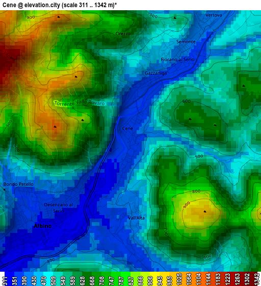
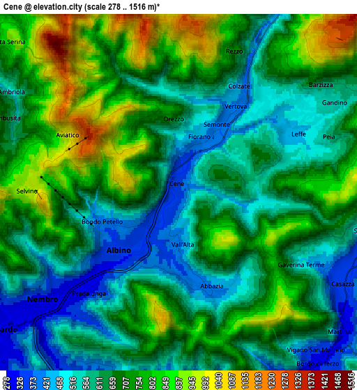
Below is the Elevation map of Cene, which displays elevation range with different colors. Scale of the first map is from 311 to 1342 m (1020 to 4403 ft) with average elevation of 593.1 meters (=1946 ft) [note 1]
These maps also provides idea of topography and contour of this city, they are displayed at different zoom levels. More info about maps, scale and edge coordinates you can find below images.
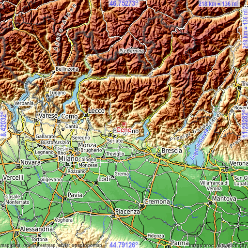
| \ | Map #1 | Map #2 | Topo.Map |
| Scale [m] | 311..1342 m | 278..1516 m | × |
| Scale [ft] | 1020..4403 ft | 912..4974 ft | × |
| Average | 593.1 m = 1946 ft | 672.7 m = 2207 ft | × |
| Width | 6.82 km = 4.2 mi | 13.63 km = 8.5 mi | 218.1 km = 135.5 mi |
| Height | 6.82 km = 4.2 mi | 13.63 km = 8.5 mi | 218.1 km = 135.5 mi |
| ↑Max Latitude | 45.811259° | 45.841882° | 46.75273° |
| Latitude at center | 45.78062° | 45.78062° | 45.78062° |
| ↓Min Latitude | 45.749964° | 45.719291° | 44.79126° |
| ← Min Longitude | 9.782625° | 9.738679° | 8.42032° |
| Longitude center | 9.82657° | 9.82657° | 9.82657° |
| →Max Longitude | 9.870515° | 9.914461° | 11.23282° |
Nearby cities:
Cities around Cene sort by population:
• Albino elevation 375 m
2.8 km,  229°
229°
• Vertova 412 m
3.7 km,  28°
28°
• Pradalunga 318 m
5.2 km,  221°
221°
• Leffe 454 m
4.9 km,  66°
66°
• Gazzaniga 372 m
1.4 km,  9°
9°
• Fiorano al Serio 392 m
2.5 km, 29°
• Casnigo 506 m
4.9 km,  42°
42°
• Abbazia 418 m
3.8 km,  161°
161°
• Colzate 437 m
4.7 km, 29°
• Vall'Alta 414 m
2.2 km,  180°
180°
• Gaverina Terme 494 m
5.4 km,  120°
120°
• Aviatico 980 m
4.7 km,  293°
293°
Multilingual:
 En español:
Cene elevación 370 m.
 En France:
Cene élévation 370 m.


Sources and notes:
- [note 1] Map square and city borders are not equal. Map elevation data is calculated only from area inside that square.
- [src 1] Elevation data from geonames database provided with same terms of usage.
- [src 2] The elevation map of Cene is generated using elevation data from NASA's 3 arcsec (90m) resolution SRTM data.
- [src 3] Base (background) map © OpenStreetMap contributors tiles are generated by Geofabrik and OpenTopoMap.
Copyright & License:
This Cene Elevation Map is licensed under CC BY-SA. You may reuse any part from this page, if you give a proper credit by linking to this URL:
 More info on terms of use page.