Gazzaniga elevation
Gazzaniga (Lombardy, Provincia di Bergamo), Italy elevation is 372 meters and Gazzaniga elevation in feet is 1220 ft above sea level [src 1]. Gazzaniga is a seat of a third-order administrative division (feature code) with elevation that is 50 meters (164 ft) bigger than average city elevation in Italy.
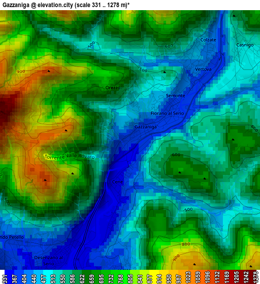
Below is the Elevation map of Gazzaniga, which displays elevation range with different colors. Scale of the first map is from 331 to 1278 m (1086 to 4193 ft) with average elevation of 615.7 meters (=2020 ft) [note 1]
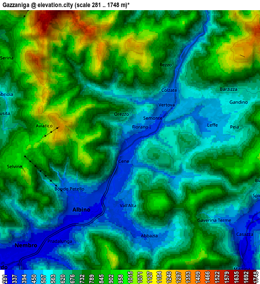
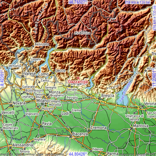
These maps also provides idea of topography and contour of this city, they are displayed at different zoom levels. More info about maps, scale and edge coordinates you can find below images.
| \ | Map #1 | Map #2 | Topo.Map |
| Scale [m] | 331..1278 m | 281..1748 m | × |
| Scale [ft] | 1086..4193 ft | 922..5735 ft | × |
| Average | 615.7 m = 2020 ft | 728.6 m = 2390 ft | × |
| Width | 6.81 km = 4.2 mi | 13.63 km = 8.5 mi | 218 km = 135.5 mi |
| Height | 6.81 km = 4.2 mi | 13.63 km = 8.5 mi | 218 km = 135.5 mi |
| ↑Max Latitude | 45.824022° | 45.854638° | 46.76527° |
| Latitude at center | 45.79339° | 45.79339° | 45.79339° |
| ↓Min Latitude | 45.762741° | 45.732075° | 44.80426° |
| ← Min Longitude | 9.785815° | 9.741869° | 8.42351° |
| Longitude center | 9.82976° | 9.82976° | 9.82976° |
| →Max Longitude | 9.873705° | 9.917651° | 11.23601° |
Nearby cities:
Cities around Gazzaniga sort by population:
• Albino elevation 375 m
4 km,  216°
216°
• Vertova 412 m
2.4 km,  39°
39°
• Leffe 454 m
4.3 km,  83°
83°
• Cene 370 m
1.4 km,  189°
189°
• Fiorano al Serio 392 m
1.3 km,  53°
53°
• Casnigo 506 m
3.7 km, 54°
• Peia 576 m
5.4 km, 82°
• Abbazia 418 m
5.1 km,  169°
169°
• Cazzano Sant'Andrea 486 m
4.7 km,  65°
65°
• Colzate 437 m
3.3 km, 37°
• Vall'Alta 414 m
3.6 km,  184°
184°
• Aviatico 980 m
4.5 km,  275°
275°
Multilingual:
 En español:
Gazzaniga elevación 372 m.
 En France:
Gazzaniga élévation 372 m.
 Auf Deutsch:
Gazzaniga höhe über dem Meeresspiegel ist 372 m.

Sources and notes:
- [note 1] Map square and city borders are not equal. Map elevation data is calculated only from area inside that square.
- [src 1] Elevation data from geonames database provided with same terms of usage.
- [src 2] The elevation map of Gazzaniga is generated using elevation data from NASA's 3 arcsec (90m) resolution SRTM data.
- [src 3] Base (background) map © OpenStreetMap contributors tiles are generated by Geofabrik and OpenTopoMap.
Copyright & License:
This Gazzaniga Elevation Map is licensed under CC BY-SA. You may reuse any part from this page, if you give a proper credit by linking to this URL:
 More info on terms of use page.