Maresso elevation
Maresso (Lombardy, Provincia di Lecco), Italy elevation is 290 meters and Maresso elevation in feet is 951 ft above sea level [src 1]. Maresso is a populated place (feature code) with elevation that is 32 meters (105 ft) smaller than average city elevation in Italy.
Below is the Elevation map of Maresso, which displays elevation range with different colors. Scale of the first map is from 218 to 495 m (715 to 1624 ft) with average elevation of 288 meters (=945 ft) [note 1]
These maps also provides idea of topography and contour of this city, they are displayed at different zoom levels. More info about maps, scale and edge coordinates you can find below images.
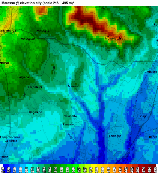
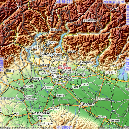
| \ | Map #1 | Topo.Map |
| Scale [m] | 218..495 m | × |
| Scale [ft] | 715..1624 ft | × |
| Average | 288 m = 945 ft | × |
| Width | 6.83 km = 4.2 mi | 218.5 km = 135.8 mi |
| Height | 6.83 km = 4.2 mi | 218.4 km = 135.7 mi |
| ↑Max Latitude | 45.71824° | 46.66129° |
| Latitude at center | 45.68755° | 45.68755° |
| ↓Min Latitude | 45.656843° | 44.69656° |
| ← Min Longitude | 9.311985° | 7.94968° |
| Longitude center | 9.35593° | 9.35593° |
| →Max Longitude | 9.399875° | 10.76218° |
Nearby cities:
Cities around Maresso sort by population:
• Usmate-Velate elevation 221 m
4.4 km,  173°
173°
• Casatenovo 356 m
3.4 km,  284°
284°
• Missaglia 302 m
2.7 km,  322°
322°
• Lomagna 258 m
2.8 km,  145°
145°
• Osnago 247 m
3.1 km,  115°
115°
• Rogoredo-Valaperta-Rimoldo 279 m
2.2 km,  236°
236°
• Monticello Brianza 381 m
4 km,  307°
307°
• Cernusco Lombardone 265 m
3.4 km,  83°
83°
• Monticello 373 m
4.2 km, 310°
• Quattro Strade 285 m
1.8 km,  61°
61°
• Campofiorenzo-California 264 m
3.7 km,  233°
233°
• Montevecchia 392 m
2.8 km,  44°
44°
Multilingual:
 En español:
Maresso elevación 290 m.
 En France:
Maresso élévation 290 m.


Sources and notes:
- [note 1] Map square and city borders are not equal. Map elevation data is calculated only from area inside that square.
- [src 1] Elevation data from geonames database provided with same terms of usage.
- [src 2] The elevation map of Maresso is generated using elevation data from NASA's 3 arcsec (90m) resolution SRTM data.
- [src 3] Base (background) map © OpenStreetMap contributors tiles are generated by Geofabrik and OpenTopoMap.
Copyright & License:
This Maresso Elevation Map is licensed under CC BY-SA. You may reuse any part from this page, if you give a proper credit by linking to this URL:
 More info on terms of use page.