Quattro Strade elevation
Quattro Strade (Lombardy, Provincia di Lecco), Italy elevation is 285 meters and Quattro Strade elevation in feet is 935 ft above sea level [src 1]. Quattro Strade is a populated place (feature code) with elevation that is 37 meters (121 ft) smaller than average city elevation in Italy.
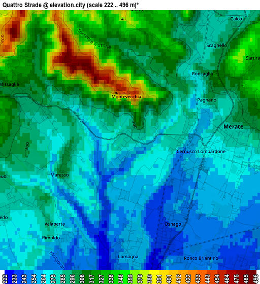
Below is the Elevation map of Quattro Strade, which displays elevation range with different colors. Scale of the first map is from 222 to 496 m (728 to 1627 ft) with average elevation of 291.4 meters (=956 ft) [note 1]
These maps also provides idea of topography and contour of this city, they are displayed at different zoom levels. More info about maps, scale and edge coordinates you can find below images.
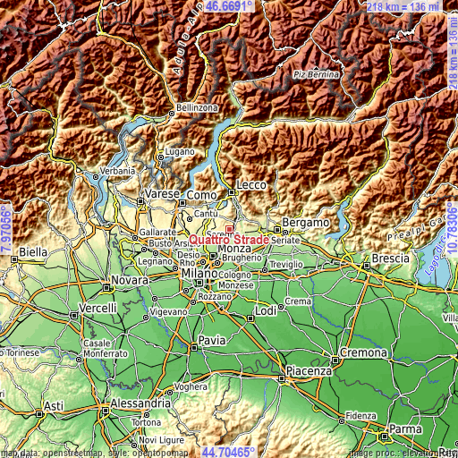
| \ | Map #1 | Topo.Map |
| Scale [m] | 222..496 m | × |
| Scale [ft] | 728..1627 ft | × |
| Average | 291.4 m = 956 ft | × |
| Width | 6.83 km = 4.2 mi | 218.4 km = 135.7 mi |
| Height | 6.83 km = 4.2 mi | 218.4 km = 135.7 mi |
| ↑Max Latitude | 45.726186° | 46.6691° |
| Latitude at center | 45.6955° | 45.6955° |
| ↓Min Latitude | 45.664797° | 44.70465° |
| ← Min Longitude | 9.332865° | 7.97056° |
| Longitude center | 9.37681° | 9.37681° |
| →Max Longitude | 9.420755° | 10.78306° |
Nearby cities:
Cities around Quattro Strade sort by population:
• Merate elevation 264 m
3.5 km,  102°
102°
• Olgiate Molgora 292 m
4.4 km,  28°
28°
• Missaglia 302 m
3.5 km,  290°
290°
• Canova-San Zeno 284 m
3.4 km, 32°
• Lomagna 258 m
3.2 km,  180°
180°
• Osnago 247 m
2.5 km,  152°
152°
• Rogoredo-Valaperta-Rimoldo 279 m
4 km,  238°
238°
• Cernusco Lombardone 265 m
1.8 km,  106°
106°
• Ronco Briantino 246 m
3.9 km, 145°
• Calco 284 m
4.2 km,  41°
41°
• Maresso 290 m
1.8 km, 241°
• Montevecchia 392 m
1.2 km,  15°
15°
Multilingual:
 En español:
Quattro Strade elevación 285 m.
 En France:
Quattro Strade élévation 285 m.
 Auf Deutsch:
Quattro Strade höhe über dem Meeresspiegel ist 285 m.

Sources and notes:
- [note 1] Map square and city borders are not equal. Map elevation data is calculated only from area inside that square.
- [src 1] Elevation data from geonames database provided with same terms of usage.
- [src 2] The elevation map of Quattro Strade is generated using elevation data from NASA's 3 arcsec (90m) resolution SRTM data.
- [src 3] Base (background) map © OpenStreetMap contributors tiles are generated by Geofabrik and OpenTopoMap.
Copyright & License:
This Quattro Strade Elevation Map is licensed under CC BY-SA. You may reuse any part from this page, if you give a proper credit by linking to this URL:
 More info on terms of use page.