Rogoredo-Valaperta-Rimoldo elevation
Rogoredo-Valaperta-Rimoldo (Lombardy, Provincia di Lecco), Italy elevation is 279 meters and Rogoredo-Valaperta-Rimoldo elevation in feet is 915 ft above sea level [src 1]. Rogoredo-Valaperta-Rimoldo is a populated place (feature code) with elevation that is 43 meters (141 ft) smaller than average city elevation in Italy.
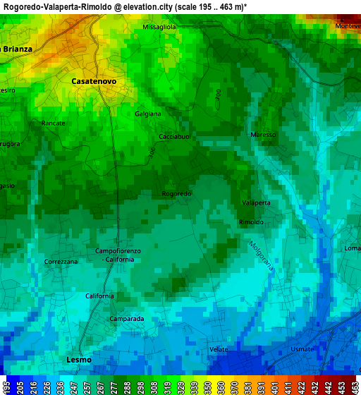
Below is the Elevation map of Rogoredo-Valaperta-Rimoldo, which displays elevation range with different colors. Scale of the first map is from 195 to 463 m (640 to 1519 ft) with average elevation of 274.5 meters (=901 ft) [note 1]
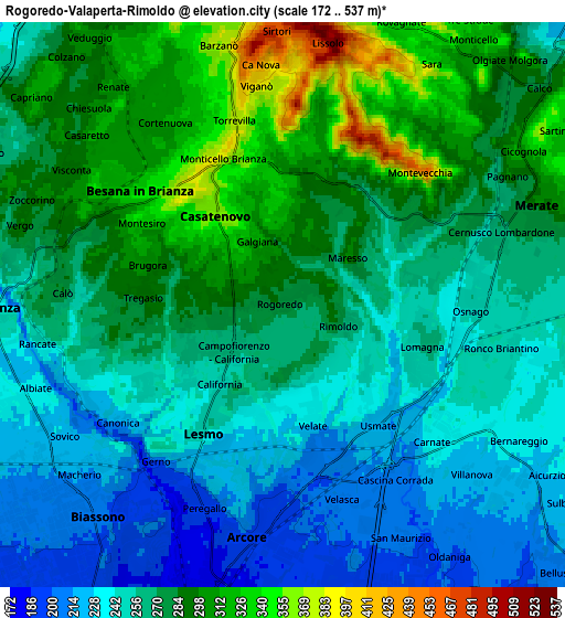
These maps also provides idea of topography and contour of this city, they are displayed at different zoom levels. More info about maps, scale and edge coordinates you can find below images.
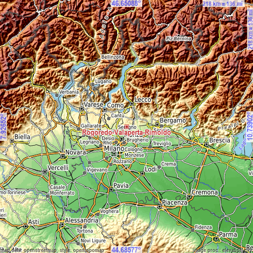
| \ | Map #1 | Map #2 | Topo.Map |
| Scale [m] | 195..463 m | 172..537 m | × |
| Scale [ft] | 640..1519 ft | 564..1762 ft | × |
| Average | 274.5 m = 901 ft | 269.1 m = 883 ft | × |
| Width | 6.83 km = 4.2 mi | 13.66 km = 8.5 mi | 218.5 km = 135.8 mi |
| Height | 6.83 km = 4.2 mi | 13.66 km = 8.5 mi | 218.5 km = 135.8 mi |
| ↑Max Latitude | 45.707646° | 45.738326° | 46.65088° |
| Latitude at center | 45.67695° | 45.67695° | 45.67695° |
| ↓Min Latitude | 45.646237° | 45.615507° | 44.68577° |
| ← Min Longitude | 9.288825° | 9.244879° | 7.92652° |
| Longitude center | 9.33277° | 9.33277° | 9.33277° |
| →Max Longitude | 9.376715° | 9.420661° | 10.73902° |
Nearby cities:
Cities around Rogoredo-Valaperta-Rimoldo sort by population:
• Usmate-Velate elevation 221 m
4 km,  144°
144°
• Lesmo 247 m
3.7 km,  212°
212°
• Casatenovo 356 m
2.5 km,  323°
323°
• Missaglia 302 m
3.3 km,  2°
2°
• Lomagna 258 m
3.6 km,  109°
109°
• Monticello Brianza 381 m
3.9 km,  339°
339°
• Correzzana 260 m
2.3 km,  239°
239°
• Camparada 242 m
2.6 km,  196°
196°
• Tregasio 284 m
3.5 km,  271°
271°
• Quattro Strade 285 m
4 km,  58°
58°
• Maresso 290 m
2.2 km, 56°
• Campofiorenzo-California 264 m
1.6 km,  229°
229°
Multilingual:
 En español:
Rogoredo-Valaperta-Rimoldo elevación 279 m.
 En France:
Rogoredo-Valaperta-Rimoldo élévation 279 m.
 Auf Deutsch:
Rogoredo-Valaperta-Rimoldo höhe über dem Meeresspiegel ist 279 m.
 На русском:
Rogoredo-Valaperta-Rimoldo высота над уровнем моря 279 м
Sources and notes:
- [note 1] Map square and city borders are not equal. Map elevation data is calculated only from area inside that square.
- [src 1] Elevation data from geonames database provided with same terms of usage.
- [src 2] The elevation map of Rogoredo-Valaperta-Rimoldo is generated using elevation data from NASA's 3 arcsec (90m) resolution SRTM data.
- [src 3] Base (background) map © OpenStreetMap contributors tiles are generated by Geofabrik and OpenTopoMap.
Copyright & License:
This Rogoredo-Valaperta-Rimoldo Elevation Map is licensed under CC BY-SA. You may reuse any part from this page, if you give a proper credit by linking to this URL:
 More info on terms of use page.