Calco elevation
Calco (Lombardy, Provincia di Lecco), Italy elevation is 284 meters and Calco elevation in feet is 932 ft above sea level [src 1]. Calco is a seat of a third-order administrative division (feature code) with elevation that is 38 meters (125 ft) smaller than average city elevation in Italy.
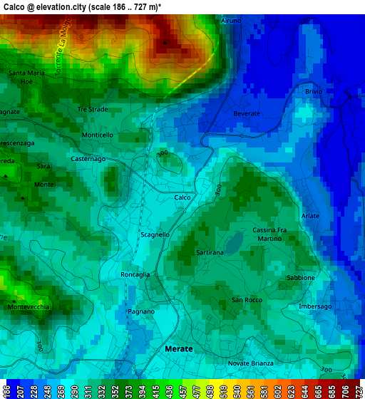
Below is the Elevation map of Calco, which displays elevation range with different colors. Scale of the first map is from 186 to 727 m (610 to 2385 ft) with average elevation of 316.9 meters (=1040 ft) [note 1]
These maps also provides idea of topography and contour of this city, they are displayed at different zoom levels. More info about maps, scale and edge coordinates you can find below images.
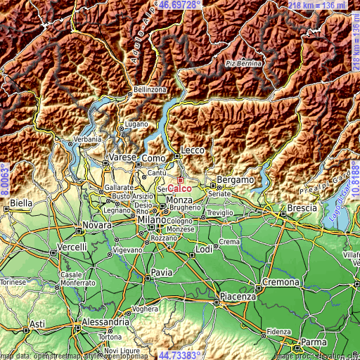
| \ | Map #1 | Topo.Map |
| Scale [m] | 186..727 m | × |
| Scale [ft] | 610..2385 ft | × |
| Average | 316.9 m = 1040 ft | × |
| Width | 6.82 km = 4.2 mi | 218.3 km = 135.6 mi |
| Height | 6.82 km = 4.2 mi | 218.3 km = 135.6 mi |
| ↑Max Latitude | 45.75485° | 46.69728° |
| Latitude at center | 45.72418° | 45.72418° |
| ↓Min Latitude | 45.693493° | 44.73383° |
| ← Min Longitude | 9.368605° | 8.0063° |
| Longitude center | 9.41255° | 9.41255° |
| →Max Longitude | 9.456495° | 10.8188° |
Nearby cities:
Cities around Calco sort by population:
• Merate elevation 264 m
4 km,  170°
170°
• Olgiate Molgora 292 m
1 km,  313°
313°
• Canova-San Zeno 284 m
1 km,  250°
250°
• Brivio 272 m
2.7 km,  57°
57°
• Villa d'Adda 252 m
4 km,  106°
106°
• Cernusco Lombardone 265 m
3.8 km,  195°
195°
• Airuno 212 m
3.5 km,  19°
19°
• Imbersago 261 m
3.2 km,  129°
129°
• Rovagnate 337 m
3.5 km,  293°
293°
• Santa Maria Hoè 380 m
3.7 km, 307°
• Arlate 235 m
2.3 km,  91°
91°
• Montevecchia 392 m
3.2 km,  229°
229°
Multilingual:
 En español:
Calco elevación 284 m.
 En France:
Calco élévation 284 m.


Sources and notes:
- [note 1] Map square and city borders are not equal. Map elevation data is calculated only from area inside that square.
- [src 1] Elevation data from geonames database provided with same terms of usage.
- [src 2] The elevation map of Calco is generated using elevation data from NASA's 3 arcsec (90m) resolution SRTM data.
- [src 3] Base (background) map © OpenStreetMap contributors tiles are generated by Geofabrik and OpenTopoMap.
Copyright & License:
This Calco Elevation Map is licensed under CC BY-SA. You may reuse any part from this page, if you give a proper credit by linking to this URL:
 More info on terms of use page.