Arlate elevation
Arlate (Lombardy, Provincia di Lecco), Italy elevation is 235 meters and Arlate elevation in feet is 771 ft above sea level [src 1]. Arlate is a populated place (feature code) with elevation that is 87 meters (285 ft) smaller than average city elevation in Italy.
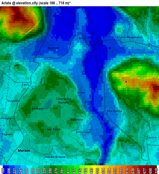
Below is the Elevation map of Arlate, which displays elevation range with different colors. Scale of the first map is from 186 to 718 m (610 to 2356 ft) with average elevation of 301.9 meters (=990 ft) [note 1]
These maps also provides idea of topography and contour of this city, they are displayed at different zoom levels. More info about maps, scale and edge coordinates you can find below images.
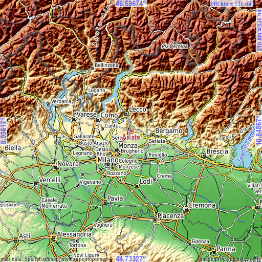
| \ | Map #1 | Topo.Map |
| Scale [m] | 186..718 m | × |
| Scale [ft] | 610..2356 ft | × |
| Average | 301.9 m = 990 ft | × |
| Width | 6.82 km = 4.2 mi | 218.3 km = 135.6 mi |
| Height | 6.82 km = 4.2 mi | 218.3 km = 135.6 mi |
| ↑Max Latitude | 45.754301° | 46.69674° |
| Latitude at center | 45.72363° | 45.72363° |
| ↓Min Latitude | 45.692942° | 44.73327° |
| ← Min Longitude | 9.398475° | 8.03617° |
| Longitude center | 9.44242° | 9.44242° |
| →Max Longitude | 9.486365° | 10.84867° |
Nearby cities:
Cities around Arlate sort by population:
• Merate elevation 264 m
4.2 km,  203°
203°
• Calusco d'Adda 269 m
4.5 km,  150°
150°
• Olgiate Molgora 292 m
3.1 km,  283°
283°
• Robbiate 268 m
4 km,  185°
185°
• Canova-San Zeno 284 m
3.3 km,  265°
265°
• Cisano Bergamasco 265 m
3 km,  47°
47°
• Brivio 272 m
1.5 km,  0°
0°
• Carvico 276 m
4.1 km,  125°
125°
• Villa d'Adda 252 m
1.8 km, 125°
• Calco 284 m
2.3 km, 271°
• Airuno 212 m
3.5 km,  340°
340°
• Imbersago 261 m
2 km,  175°
175°
Multilingual:
 En español:
Arlate elevación 235 m.
 En France:
Arlate élévation 235 m.


Sources and notes:
- [note 1] Map square and city borders are not equal. Map elevation data is calculated only from area inside that square.
- [src 1] Elevation data from geonames database provided with same terms of usage.
- [src 2] The elevation map of Arlate is generated using elevation data from NASA's 3 arcsec (90m) resolution SRTM data.
- [src 3] Base (background) map © OpenStreetMap contributors tiles are generated by Geofabrik and OpenTopoMap.
Copyright & License:
This Arlate Elevation Map is licensed under CC BY-SA. You may reuse any part from this page, if you give a proper credit by linking to this URL:
 More info on terms of use page.