Turate elevation
Turate (Lombardy, Provincia di Como), Italy elevation is 245 meters and Turate elevation in feet is 804 ft above sea level [src 1]. Turate is a seat of a third-order administrative division (feature code) with elevation that is 77 meters (253 ft) smaller than average city elevation in Italy.
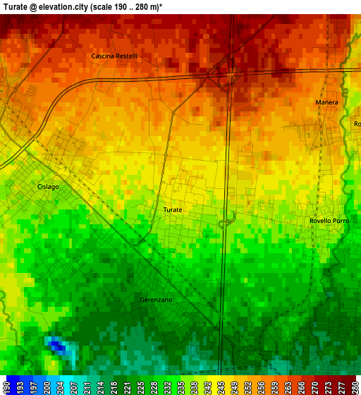
Below is the Elevation map of Turate, which displays elevation range with different colors. Scale of the first map is from 190 to 280 m (623 to 919 ft) with average elevation of 242 meters (=794 ft) [note 1]
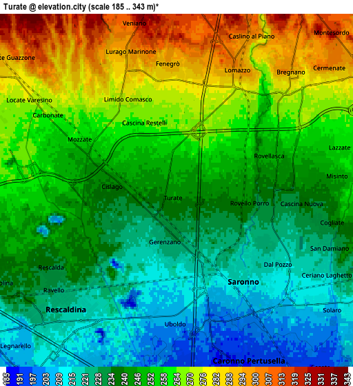
These maps also provides idea of topography and contour of this city, they are displayed at different zoom levels. More info about maps, scale and edge coordinates you can find below images.
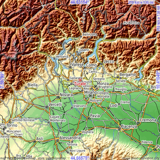
| \ | Map #1 | Map #2 | Topo.Map |
| Scale [m] | 190..280 m | 185..343 m | × |
| Scale [ft] | 623..919 ft | 607..1125 ft | × |
| Average | 242 m = 794 ft | 248.2 m = 814 ft | × |
| Width | 6.83 km = 4.2 mi | 13.66 km = 8.5 mi | 218.6 km = 135.8 mi |
| Height | 6.83 km = 4.2 mi | 13.66 km = 8.5 mi | 218.6 km = 135.8 mi |
| ↑Max Latitude | 45.687977° | 45.718667° | 46.63154° |
| Latitude at center | 45.65727° | 45.65727° | 45.65727° |
| ↓Min Latitude | 45.626546° | 45.595805° | 44.66575° |
| ← Min Longitude | 8.960295° | 8.916349° | 7.59799° |
| Longitude center | 9.00424° | 9.00424° | 9.00424° |
| →Max Longitude | 9.048185° | 9.092131° | 10.41049° |
Nearby cities:
Cities around Turate sort by population:
• Saronno elevation 215 m
4.3 km,  146°
146°
• Gerenzano 226 m
2 km,  187°
187°
• Uboldo 207 m
4.7 km,  180°
180°
• Cislago 239 m
2.5 km,  275°
275°
• Mozzate 259 m
4.2 km,  297°
297°
• Lomazzo 292 m
5 km,  28°
28°
• Rovellasca 247 m
3.6 km,  73°
73°
• Rovello Porro 239 m
2.8 km,  101°
101°
• Fenegrò 295 m
4.9 km,  355°
355°
• Limido Comasco 277 m
4 km,  331°
331°
• Cirimido 293 m
4.8 km,  7°
7°
• Manera 258 m
3.3 km,  57°
57°
Multilingual:
 En español:
Turate elevación 245 m.
 En France:
Turate élévation 245 m.


Sources and notes:
- [note 1] Map square and city borders are not equal. Map elevation data is calculated only from area inside that square.
- [src 1] Elevation data from geonames database provided with same terms of usage.
- [src 2] The elevation map of Turate is generated using elevation data from NASA's 3 arcsec (90m) resolution SRTM data.
- [src 3] Base (background) map © OpenStreetMap contributors tiles are generated by Geofabrik and OpenTopoMap.
Copyright & License:
This Turate Elevation Map is licensed under CC BY-SA. You may reuse any part from this page, if you give a proper credit by linking to this URL:
 More info on terms of use page.