Cirimido elevation
Cirimido (Lombardy, Provincia di Como), Italy elevation is 293 meters and Cirimido elevation in feet is 961 ft above sea level [src 1]. Cirimido is a seat of a third-order administrative division (feature code) with elevation that is 29 meters (95 ft) smaller than average city elevation in Italy.
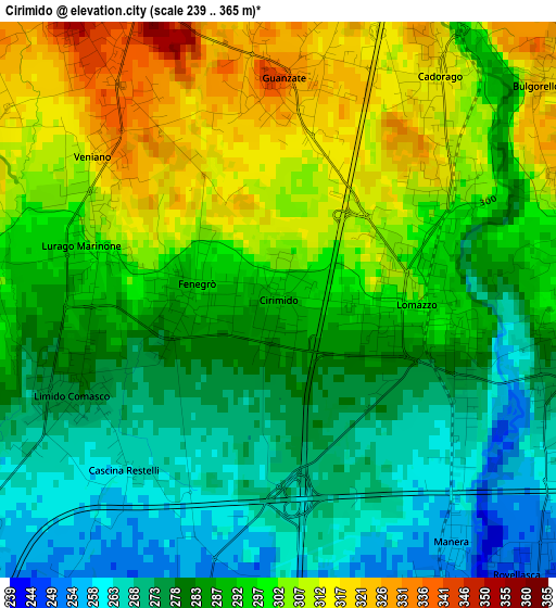
Below is the Elevation map of Cirimido, which displays elevation range with different colors. Scale of the first map is from 239 to 365 m (784 to 1198 ft) with average elevation of 290.4 meters (=953 ft) [note 1]
These maps also provides idea of topography and contour of this city, they are displayed at different zoom levels. More info about maps, scale and edge coordinates you can find below images.
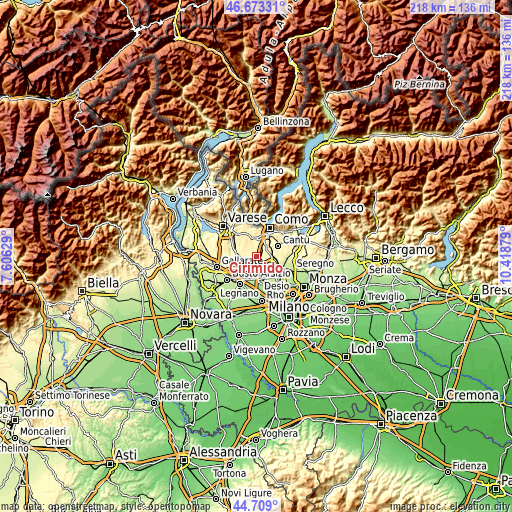
| \ | Map #1 | Topo.Map |
| Scale [m] | 239..365 m | × |
| Scale [ft] | 784..1198 ft | × |
| Average | 290.4 m = 953 ft | × |
| Width | 6.83 km = 4.2 mi | 218.4 km = 135.7 mi |
| Height | 6.83 km = 4.2 mi | 218.4 km = 135.7 mi |
| ↑Max Latitude | 45.730464° | 46.67331° |
| Latitude at center | 45.69978° | 45.69978° |
| ↓Min Latitude | 45.669079° | 44.709° |
| ← Min Longitude | 8.968595° | 7.60629° |
| Longitude center | 9.01254° | 9.01254° |
| →Max Longitude | 9.056485° | 10.41879° |
Nearby cities:
Cities around Cirimido sort by population:
• Lomazzo elevation 292 m
1.7 km,  101°
101°
• Cadorago-Caslino al Piano 315 m
3.6 km,  32°
32°
• Guanzate 319 m
3.1 km,  10°
10°
• Bregnano 297 m
3.6 km,  93°
93°
• San Michele-San Giorgio 285 m
3.6 km, 96°
• Fenegrò 295 m
1 km,  281°
281°
• Veniano 331 m
2.8 km,  310°
310°
• Limido Comasco 277 m
2.8 km,  245°
245°
• Lurago Marinone 301 m
2.3 km, 283°
• Manera 258 m
3.6 km,  143°
143°
• Puginate 307 m
3.7 km,  70°
70°
• Bulgorello 318 m
4.3 km,  50°
50°
Multilingual:
 En español:
Cirimido elevación 293 m.
 En France:
Cirimido élévation 293 m.
 Auf Deutsch:
Cirimido höhe über dem Meeresspiegel ist 293 m.

Sources and notes:
- [note 1] Map square and city borders are not equal. Map elevation data is calculated only from area inside that square.
- [src 1] Elevation data from geonames database provided with same terms of usage.
- [src 2] The elevation map of Cirimido is generated using elevation data from NASA's 3 arcsec (90m) resolution SRTM data.
- [src 3] Base (background) map © OpenStreetMap contributors tiles are generated by Geofabrik and OpenTopoMap.
Copyright & License:
This Cirimido Elevation Map is licensed under CC BY-SA. You may reuse any part from this page, if you give a proper credit by linking to this URL:
 More info on terms of use page.