Manera elevation
Manera (Lombardy, Provincia di Como), Italy elevation is 258 meters and Manera elevation in feet is 846 ft above sea level [src 1]. Manera is a populated place (feature code) with elevation that is 64 meters (210 ft) smaller than average city elevation in Italy.
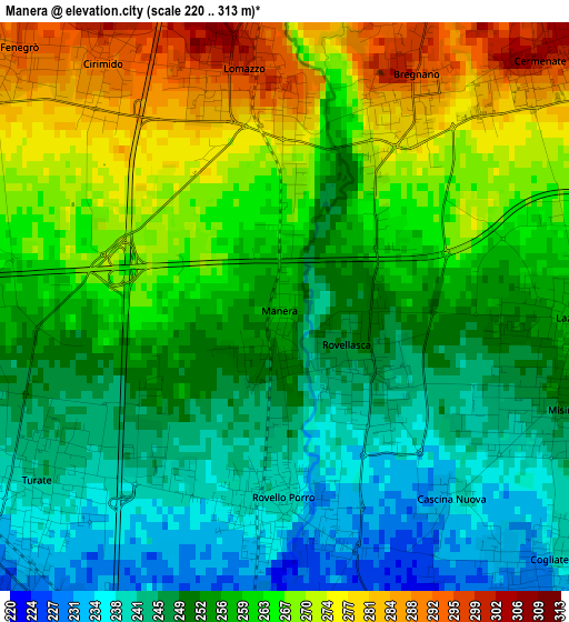
Below is the Elevation map of Manera, which displays elevation range with different colors. Scale of the first map is from 220 to 313 m (722 to 1027 ft) with average elevation of 257.3 meters (=844 ft) [note 1]
These maps also provides idea of topography and contour of this city, they are displayed at different zoom levels. More info about maps, scale and edge coordinates you can find below images.
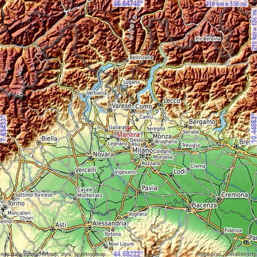
| \ | Map #1 | Topo.Map |
| Scale [m] | 220..313 m | × |
| Scale [ft] | 722..1027 ft | × |
| Average | 257.3 m = 844 ft | × |
| Width | 6.83 km = 4.2 mi | 218.5 km = 135.8 mi |
| Height | 6.83 km = 4.2 mi | 218.5 km = 135.8 mi |
| ↑Max Latitude | 45.704158° | 46.64745° |
| Latitude at center | 45.67346° | 45.67346° |
| ↓Min Latitude | 45.642745° | 44.68222° |
| ← Min Longitude | 8.996635° | 7.63433° |
| Longitude center | 9.04058° | 9.04058° |
| →Max Longitude | 9.084525° | 10.44683° |
Nearby cities:
Cities around Manera sort by population:
• Turate elevation 245 m
3.3 km,  237°
237°
• Cogliate 231 m
4.3 km,  135°
135°
• Lomazzo 292 m
2.6 km,  349°
349°
• Lazzate 259 m
3.4 km,  92°
92°
• Rovellasca 247 m
1 km, 139°
• Rovello Porro 239 m
2.4 km,  182°
182°
• Bregnano 297 m
3.1 km,  28°
28°
• San Michele-San Giorgio 285 m
2.9 km, 29°
• Misinto 247 m
3.4 km,  112°
112°
• Fenegrò 295 m
4.5 km,  314°
314°
• Cirimido 293 m
3.6 km,  323°
323°
• Puginate 307 m
4.4 km,  17°
17°
Multilingual:
 En español:
Manera elevación 258 m.
 En France:
Manera élévation 258 m.


Sources and notes:
- [note 1] Map square and city borders are not equal. Map elevation data is calculated only from area inside that square.
- [src 1] Elevation data from geonames database provided with same terms of usage.
- [src 2] The elevation map of Manera is generated using elevation data from NASA's 3 arcsec (90m) resolution SRTM data.
- [src 3] Base (background) map © OpenStreetMap contributors tiles are generated by Geofabrik and OpenTopoMap.
Copyright & License:
This Manera Elevation Map is licensed under CC BY-SA. You may reuse any part from this page, if you give a proper credit by linking to this URL:
 More info on terms of use page.