Ternengo elevation
Ternengo (Piedmont, Provincia di Biella), Italy elevation is 440 meters and Ternengo elevation in feet is 1444 ft above sea level [src 1]. Ternengo is a seat of a third-order administrative division (feature code) with elevation that is 118 meters (387 ft) bigger than average city elevation in Italy.
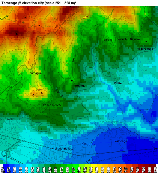
Below is the Elevation map of Ternengo, which displays elevation range with different colors. Scale of the first map is from 251 to 828 m (823 to 2717 ft) with average elevation of 447.9 meters (=1469 ft) [note 1]
These maps also provides idea of topography and contour of this city, they are displayed at different zoom levels. More info about maps, scale and edge coordinates you can find below images.
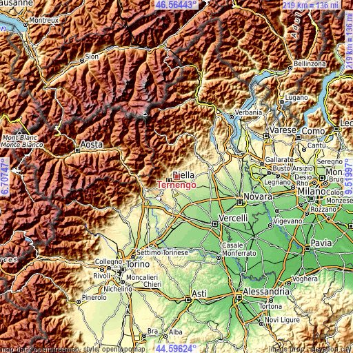
| \ | Map #1 | Topo.Map |
| Scale [m] | 251..828 m | × |
| Scale [ft] | 823..2717 ft | × |
| Average | 447.9 m = 1469 ft | × |
| Width | 6.84 km = 4.3 mi | 218.8 km = 136 mi |
| Height | 6.84 km = 4.3 mi | 218.8 km = 136 mi |
| ↑Max Latitude | 45.619705° | 46.56443° |
| Latitude at center | 45.58896° | 45.58896° |
| ↓Min Latitude | 45.558199° | 44.59624° |
| ← Min Longitude | 8.069775° | 6.70747° |
| Longitude center | 8.11372° | 8.11372° |
| →Max Longitude | 8.157665° | 9.51997° |
Nearby cities:
Cities around Ternengo sort by population:
• Vigliano Biellese elevation 323 m
2.9 km,  193°
193°
• Valdengo 275 m
3.1 km,  141°
141°
• Pettinengo 713 m
2.8 km,  344°
344°
• Quaregna 258 m
4 km,  102°
102°
• Ronco Biellese 462 m
2.1 km,  236°
236°
• Livera 676 m
2.7 km,  346°
346°
• Zumaglia 587 m
2 km,  286°
286°
• Bioglio-Portula-Andrè 594 m
3.4 km,  30°
30°
• Piatto 383 m
1.7 km,  86°
86°
• Vallanzengo 416 m
3.3 km,  60°
60°
• Maglione-Crosa 412 m
3.2 km, 60°
• Valle San Nicolao 466 m
2.9 km,  46°
46°
Multilingual:
 En español:
Ternengo elevación 440 m.
 En France:
Ternengo élévation 440 m.
 Auf Deutsch:
Ternengo höhe über dem Meeresspiegel ist 440 m.

Sources and notes:
- [note 1] Map square and city borders are not equal. Map elevation data is calculated only from area inside that square.
- [src 1] Elevation data from geonames database provided with same terms of usage.
- [src 2] The elevation map of Ternengo is generated using elevation data from NASA's 3 arcsec (90m) resolution SRTM data.
- [src 3] Base (background) map © OpenStreetMap contributors tiles are generated by Geofabrik and OpenTopoMap.
Copyright & License:
This Ternengo Elevation Map is licensed under CC BY-SA. You may reuse any part from this page, if you give a proper credit by linking to this URL:
 More info on terms of use page.