Maglione-Crosa elevation
Maglione-Crosa (Piedmont, Provincia di Biella), Italy elevation is 412 meters and Maglione-Crosa elevation in feet is 1352 ft above sea level [src 1]. Maglione-Crosa is a seat of a third-order administrative division (feature code) with elevation that is 90 meters (295 ft) bigger than average city elevation in Italy.
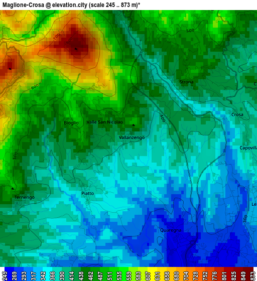
Below is the Elevation map of Maglione-Crosa, which displays elevation range with different colors. Scale of the first map is from 245 to 873 m (804 to 2864 ft) with average elevation of 430.8 meters (=1413 ft) [note 1]
These maps also provides idea of topography and contour of this city, they are displayed at different zoom levels. More info about maps, scale and edge coordinates you can find below images.
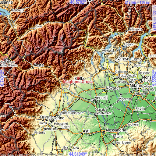
| \ | Map #1 | Topo.Map |
| Scale [m] | 245..873 m | × |
| Scale [ft] | 804..2864 ft | × |
| Average | 430.8 m = 1413 ft | × |
| Width | 6.84 km = 4.3 mi | 218.8 km = 136 mi |
| Height | 6.84 km = 4.3 mi | 218.8 km = 136 mi |
| ↑Max Latitude | 45.633707° | 46.5782° |
| Latitude at center | 45.60297° | 45.60297° |
| ↓Min Latitude | 45.572216° | 44.61049° |
| ← Min Longitude | 8.105425° | 6.74312° |
| Longitude center | 8.14937° | 8.14937° |
| →Max Longitude | 8.193315° | 9.55562° |
Nearby cities:
Cities around Maglione-Crosa sort by population:
• Valle Mosso elevation 421 m
3.1 km,  357°
357°
• Pettinengo 713 m
3.7 km,  287°
287°
• Lessona 330 m
3.9 km,  117°
117°
• Quaregna 258 m
2.7 km,  155°
155°
• Livera 676 m
3.6 km, 287°
• Bioglio-Portula-Andrè 594 m
1.7 km,  322°
322°
• Fontanella-Ozino 461 m
2.4 km,  39°
39°
• Casapinta 431 m
3.9 km,  68°
68°
• Piatto 383 m
1.8 km,  216°
216°
• Ternengo 440 m
3.2 km,  240°
240°
• Vallanzengo 416 m
0.1 km, 67°
• Valle San Nicolao 466 m
0.8 km,  304°
304°
Multilingual:
 En español:
Maglione-Crosa elevación 412 m.
 En France:
Crosa élévation 412 m.


Sources and notes:
- [note 1] Map square and city borders are not equal. Map elevation data is calculated only from area inside that square.
- [src 1] Elevation data from geonames database provided with same terms of usage.
- [src 2] The elevation map of Maglione-Crosa is generated using elevation data from NASA's 3 arcsec (90m) resolution SRTM data.
- [src 3] Base (background) map © OpenStreetMap contributors tiles are generated by Geofabrik and OpenTopoMap.
Copyright & License:
This Maglione-Crosa Elevation Map is licensed under CC BY-SA. You may reuse any part from this page, if you give a proper credit by linking to this URL:
 More info on terms of use page.