Brienza elevation
Brienza (Basilicate, Provincia di Potenza), Italy elevation is 695 meters and Brienza elevation in feet is 2280 ft above sea level [src 1]. Brienza is a seat of a third-order administrative division (feature code) with elevation that is 373 meters (1224 ft) bigger than average city elevation in Italy.
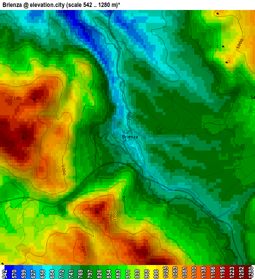
Below is the Elevation map of Brienza, which displays elevation range with different colors. Scale of the first map is from 542 to 1280 m (1778 to 4199 ft) with average elevation of 863.3 meters (=2832 ft) [note 1]
These maps also provides idea of topography and contour of this city, they are displayed at different zoom levels. More info about maps, scale and edge coordinates you can find below images.
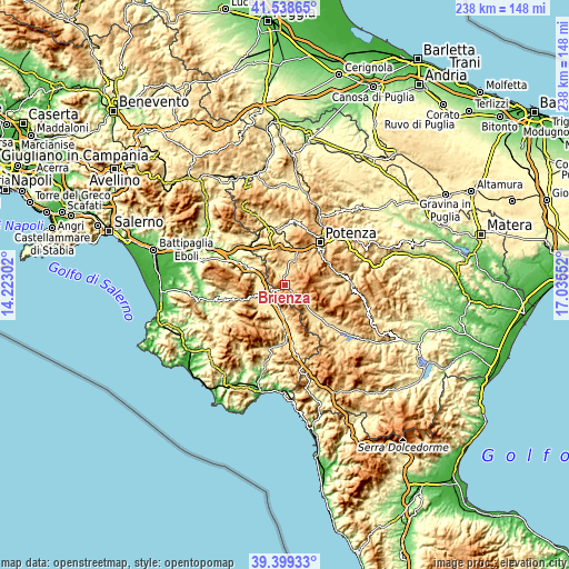
| \ | Map #1 | Topo.Map |
| Scale [m] | 542..1280 m | × |
| Scale [ft] | 1778..4199 ft | × |
| Average | 863.3 m = 2832 ft | × |
| Width | 7.43 km = 4.6 mi | 237.9 km = 147.8 mi |
| Height | 7.43 km = 4.6 mi | 237.9 km = 147.8 mi |
| ↑Max Latitude | 40.510929° | 41.53865° |
| Latitude at center | 40.47751° | 40.47751° |
| ↓Min Latitude | 40.444074° | 39.39933° |
| ← Min Longitude | 15.585325° | 14.22302° |
| Longitude center | 15.62927° | 15.62927° |
| →Max Longitude | 15.673215° | 17.03552° |
Nearby cities:
Cities around Brienza sort by population:
• Sala Consilina elevation 542 m
9.1 km,  200°
200°
• Polla 445 m
11.9 km,  290°
290°
• Tito 621 m
12.5 km,  18°
18°
• Prato Perillo 458 m
12.6 km,  224°
224°
• Sant'Arsenio 448 m
12.3 km,  266°
266°
• Satriano di Lucania 661 m
7.3 km,  7°
7°
• Marsico Nuovo 847 m
10.7 km,  123°
123°
• San Pietro al Tanagro 455 m
12.3 km,  258°
258°
• Atena Lucana 630 m
6.7 km,  247°
247°
• Sant'Angelo le Fratte 534 m
9.4 km,  322°
322°
• Sasso di Castalda 914 m
4 km,  77°
77°
• Savoia di Lucania 707 m
12.2 km,  327°
327°
Multilingual:
 En español:
Brienza elevación 695 m.
 En France:
Brienza élévation 695 m.


Sources and notes:
- [note 1] Map square and city borders are not equal. Map elevation data is calculated only from area inside that square.
- [src 1] Elevation data from geonames database provided with same terms of usage.
- [src 2] The elevation map of Brienza is generated using elevation data from NASA's 3 arcsec (90m) resolution SRTM data.
- [src 3] Base (background) map © OpenStreetMap contributors tiles are generated by Geofabrik and OpenTopoMap.
Copyright & License:
This Brienza Elevation Map is licensed under CC BY-SA. You may reuse any part from this page, if you give a proper credit by linking to this URL:
 More info on terms of use page.