Tito elevation
Tito (Basilicate, Provincia di Potenza), Italy elevation is 621 meters and Tito elevation in feet is 2037 ft above sea level [src 1]. Tito is a seat of a third-order administrative division (feature code) with elevation that is 299 meters (981 ft) bigger than average city elevation in Italy.
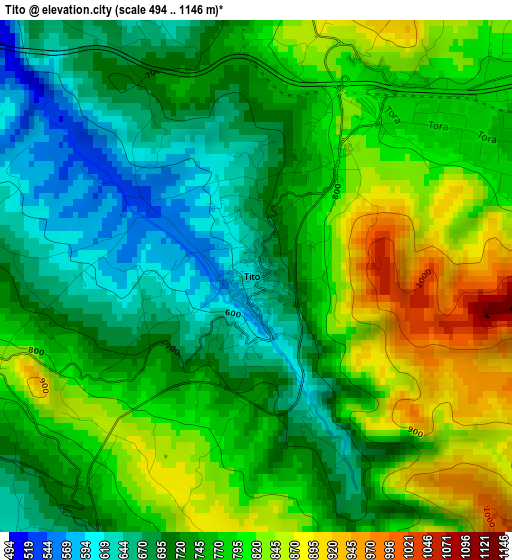
Below is the Elevation map of Tito, which displays elevation range with different colors. Scale of the first map is from 494 to 1146 m (1621 to 3760 ft) with average elevation of 756.8 meters (=2483 ft) [note 1]
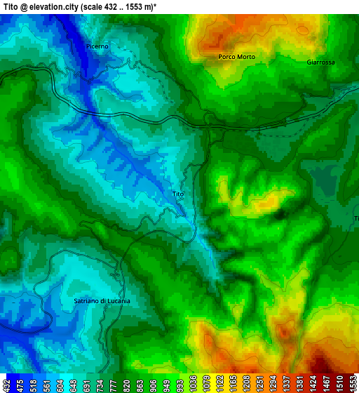
These maps also provides idea of topography and contour of this city, they are displayed at different zoom levels. More info about maps, scale and edge coordinates you can find below images.
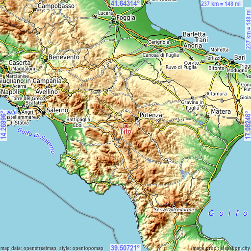
| \ | Map #1 | Map #2 | Topo.Map |
| Scale [m] | 494..1146 m | 432..1553 m | × |
| Scale [ft] | 1621..3760 ft | 1417..5095 ft | × |
| Average | 756.8 m = 2483 ft | 818.2 m = 2684 ft | × |
| Width | 7.42 km = 4.6 mi | 14.84 km = 9.2 mi | 237.5 km = 147.6 mi |
| Height | 7.42 km = 4.6 mi | 14.84 km = 9.2 mi | 237.5 km = 147.6 mi |
| ↑Max Latitude | 40.617066° | 40.650416° | 41.64314° |
| Latitude at center | 40.5837° | 40.5837° | 40.5837° |
| ↓Min Latitude | 40.550317° | 40.516918° | 39.50721° |
| ← Min Longitude | 15.632265° | 15.588319° | 14.26996° |
| Longitude center | 15.67621° | 15.67621° | 15.67621° |
| →Max Longitude | 15.720155° | 15.764101° | 17.08246° |
Nearby cities:
Cities around Tito sort by population:
• Potenza elevation 760 m
12.9 km,  59°
59°
• Pignola 898 m
9.1 km,  96°
96°
• Picerno 637 m
6.9 km,  335°
335°
• Brienza 695 m
12.5 km,  198°
198°
• Vietri di Potenza 390 m
14.3 km,  277°
277°
• Satriano di Lucania 661 m
5.5 km,  213°
213°
• Ruoti 705 m
14.8 km,  2°
2°
• Abriola 944 m
14.3 km,  126°
126°
• Sant'Angelo le Fratte 534 m
10.6 km,  245°
245°
• Sasso di Castalda 914 m
10.9 km,  180°
180°
• Baragiano 616 m
12.8 km,  327°
327°
• Savoia di Lucania 707 m
10.7 km,  261°
261°
Multilingual:
 En español:
Tito elevación 621 m.
 En France:
Tito élévation 621 m.


Sources and notes:
- [note 1] Map square and city borders are not equal. Map elevation data is calculated only from area inside that square.
- [src 1] Elevation data from geonames database provided with same terms of usage.
- [src 2] The elevation map of Tito is generated using elevation data from NASA's 3 arcsec (90m) resolution SRTM data.
- [src 3] Base (background) map © OpenStreetMap contributors tiles are generated by Geofabrik and OpenTopoMap.
Copyright & License:
This Tito Elevation Map is licensed under CC BY-SA. You may reuse any part from this page, if you give a proper credit by linking to this URL:
 More info on terms of use page.