Baragiano elevation
Baragiano (Basilicate, Provincia di Potenza), Italy elevation is 616 meters and Baragiano elevation in feet is 2021 ft above sea level [src 1]. Baragiano is a seat of a third-order administrative division (feature code) with elevation that is 294 meters (965 ft) bigger than average city elevation in Italy.
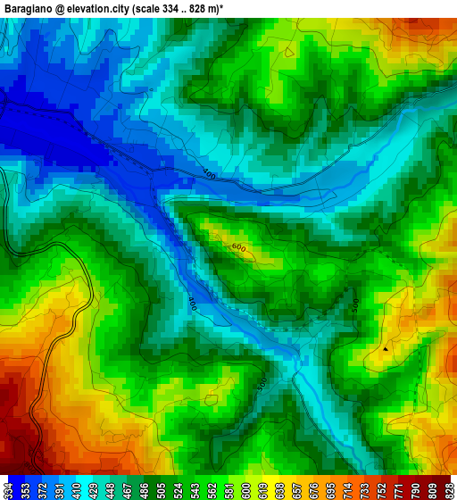
Below is the Elevation map of Baragiano, which displays elevation range with different colors. Scale of the first map is from 334 to 828 m (1096 to 2717 ft) with average elevation of 512.4 meters (=1681 ft) [note 1]
These maps also provides idea of topography and contour of this city, they are displayed at different zoom levels. More info about maps, scale and edge coordinates you can find below images.
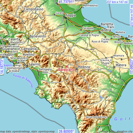
| \ | Map #1 | Topo.Map |
| Scale [m] | 334..828 m | × |
| Scale [ft] | 1096..2717 ft | × |
| Average | 512.4 m = 1681 ft | × |
| Width | 7.41 km = 4.6 mi | 237.2 km = 147.4 mi |
| Height | 7.41 km = 4.6 mi | 237.1 km = 147.3 mi |
| ↑Max Latitude | 40.713328° | 41.73791° |
| Latitude at center | 40.68001° | 40.68001° |
| ↓Min Latitude | 40.646675° | 39.60505° |
| ← Min Longitude | 15.550035° | 14.18773° |
| Longitude center | 15.59398° | 15.59398° |
| →Max Longitude | 15.637925° | 17.00023° |
Nearby cities:
Cities around Baragiano sort by population:
• Avigliano elevation 894 m
12.1 km,  61°
61°
• Tito 621 m
12.8 km,  147°
147°
• Muro Lucano 577 m
12.1 km,  312°
312°
• Picerno 637 m
6.1 km,  137°
137°
• Bella 674 m
10 km,  333°
333°
• Vietri di Potenza 390 m
11.5 km,  219°
219°
• Ruoti 705 m
8.6 km, 61°
• Balvano 424 m
7.6 km,  243°
243°
• Ricigliano 594 m
9.9 km,  262°
262°
• Scalo di Baragiano 374 m
2.3 km,  316°
316°
• Savoia di Lucania 707 m
12.8 km,  196°
196°
• Scalo Romagnano al Monte 209 m
14.6 km, 237°
Multilingual:
 En español:
Baragiano elevación 616 m.
 En France:
Baragiano élévation 616 m.
 Auf Deutsch:
Baragiano höhe über dem Meeresspiegel ist 616 m.

Sources and notes:
- [note 1] Map square and city borders are not equal. Map elevation data is calculated only from area inside that square.
- [src 1] Elevation data from geonames database provided with same terms of usage.
- [src 2] The elevation map of Baragiano is generated using elevation data from NASA's 3 arcsec (90m) resolution SRTM data.
- [src 3] Base (background) map © OpenStreetMap contributors tiles are generated by Geofabrik and OpenTopoMap.
Copyright & License:
This Baragiano Elevation Map is licensed under CC BY-SA. You may reuse any part from this page, if you give a proper credit by linking to this URL:
 More info on terms of use page.