Ruoti elevation
Ruoti (Basilicate, Provincia di Potenza), Italy elevation is 705 meters and Ruoti elevation in feet is 2313 ft above sea level [src 1]. Ruoti is a seat of a third-order administrative division (feature code) with elevation that is 383 meters (1257 ft) bigger than average city elevation in Italy.
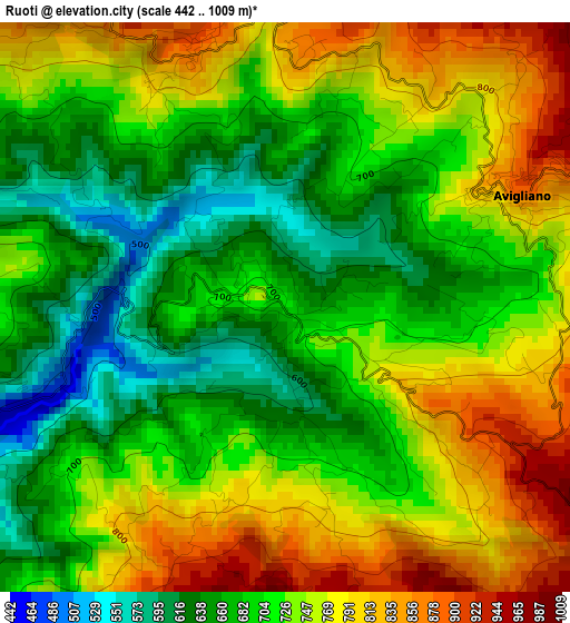
Below is the Elevation map of Ruoti, which displays elevation range with different colors. Scale of the first map is from 442 to 1009 m (1450 to 3310 ft) with average elevation of 723.7 meters (=2374 ft) [note 1]
These maps also provides idea of topography and contour of this city, they are displayed at different zoom levels. More info about maps, scale and edge coordinates you can find below images.
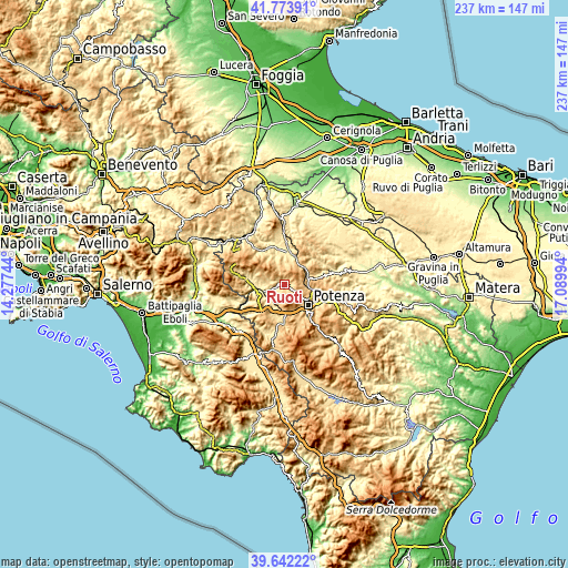
| \ | Map #1 | Topo.Map |
| Scale [m] | 442..1009 m | × |
| Scale [ft] | 1450..3310 ft | × |
| Average | 723.7 m = 2374 ft | × |
| Width | 7.41 km = 4.6 mi | 237 km = 147.3 mi |
| Height | 7.41 km = 4.6 mi | 237 km = 147.3 mi |
| ↑Max Latitude | 40.7499° | 41.77391° |
| Latitude at center | 40.7166° | 40.7166° |
| ↓Min Latitude | 40.683284° | 39.64222° |
| ← Min Longitude | 15.639745° | 14.27744° |
| Longitude center | 15.68369° | 15.68369° |
| →Max Longitude | 15.727635° | 17.08994° |
Nearby cities:
Cities around Ruoti sort by population:
• Potenza elevation 760 m
13.4 km,  128°
128°
• Avigliano 894 m
3.6 km,  59°
59°
• Tito 621 m
14.8 km,  182°
182°
• Muro Lucano 577 m
17 km,  284°
284°
• Picerno 637 m
9.2 km,  202°
202°
• Bella 674 m
13 km,  292°
292°
• Pietragalla 784 m
16.4 km,  78°
78°
• Balvano 424 m
16.2 km,  242°
242°
• Scalo di Baragiano 374 m
9.5 km,  255°
255°
• San Fele 884 m
16.4 km,  312°
312°
• Filiano 591 m
10.7 km,  11°
11°
• Baragiano 616 m
8.6 km, 241°
Multilingual:
 En español:
Ruoti elevación 705 m.
 En France:
Ruoti élévation 705 m.


Sources and notes:
- [note 1] Map square and city borders are not equal. Map elevation data is calculated only from area inside that square.
- [src 1] Elevation data from geonames database provided with same terms of usage.
- [src 2] The elevation map of Ruoti is generated using elevation data from NASA's 3 arcsec (90m) resolution SRTM data.
- [src 3] Base (background) map © OpenStreetMap contributors tiles are generated by Geofabrik and OpenTopoMap.
Copyright & License:
This Ruoti Elevation Map is licensed under CC BY-SA. You may reuse any part from this page, if you give a proper credit by linking to this URL:
 More info on terms of use page.