Polla elevation
Polla (Campania, Provincia di Salerno), Italy elevation is 445 meters and Polla elevation in feet is 1460 ft above sea level [src 1]. Polla is a seat of a third-order administrative division (feature code) with elevation that is 123 meters (404 ft) bigger than average city elevation in Italy.
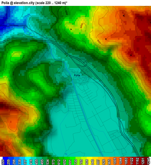
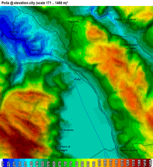
Below is the Elevation map of Polla, which displays elevation range with different colors. Scale of the first map is from 220 to 1240 m (722 to 4068 ft) with average elevation of 637.5 meters (=2092 ft) [note 1]
These maps also provides idea of topography and contour of this city, they are displayed at different zoom levels. More info about maps, scale and edge coordinates you can find below images.
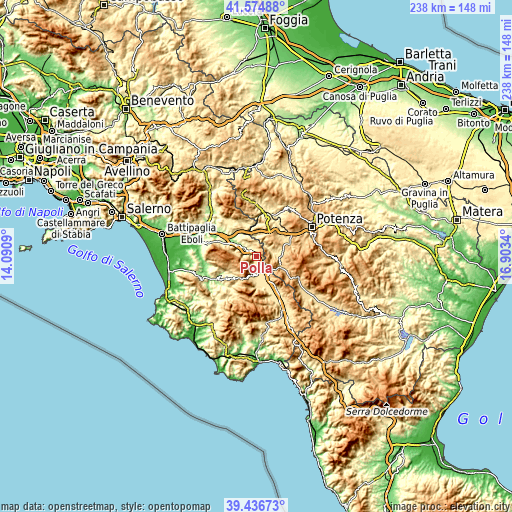
| \ | Map #1 | Map #2 | Topo.Map |
| Scale [m] | 220..1240 m | 171..1468 m | × |
| Scale [ft] | 722..4068 ft | 561..4816 ft | × |
| Average | 637.5 m = 2092 ft | 700 m = 2297 ft | × |
| Width | 7.43 km = 4.6 mi | 14.86 km = 9.2 mi | 237.7 km = 147.7 mi |
| Height | 7.43 km = 4.6 mi | 14.86 km = 9.2 mi | 237.7 km = 147.7 mi |
| ↑Max Latitude | 40.547731° | 40.581115° | 41.57488° |
| Latitude at center | 40.51433° | 40.51433° | 40.51433° |
| ↓Min Latitude | 40.480913° | 40.447478° | 39.43673° |
| ← Min Longitude | 15.453205° | 15.409259° | 14.0909° |
| Longitude center | 15.49715° | 15.49715° | 15.49715° |
| →Max Longitude | 15.541095° | 15.585041° | 16.9034° |
Nearby cities:
Cities around Polla sort by population:
• Sant'Arsenio elevation 448 m
4.9 km,  193°
193°
• Vietri di Potenza 390 m
9.6 km,  5°
5°
• Auletta 236 m
8.1 km,  309°
309°
• Caggiano 743 m
5.3 km,  359°
359°
• Petina 660 m
10.6 km,  280°
280°
• San Pietro al Tanagro 455 m
6.7 km, 187°
• Atena Lucana 630 m
8.3 km,  142°
142°
• Sant'Angelo le Fratte 534 m
6.4 km,  58°
58°
• San Rufo 652 m
9.3 km,  197°
197°
• Savoia di Lucania 707 m
7.7 km,  36°
36°
• Salvitelle 575 m
9.1 km,  338°
338°
• Pertosa 308 m
5.1 km, 309°
Multilingual:
 En español:
Polla elevación 445 m.
 En France:
Polla élévation 445 m.


Sources and notes:
- [note 1] Map square and city borders are not equal. Map elevation data is calculated only from area inside that square.
- [src 1] Elevation data from geonames database provided with same terms of usage.
- [src 2] The elevation map of Polla is generated using elevation data from NASA's 3 arcsec (90m) resolution SRTM data.
- [src 3] Base (background) map © OpenStreetMap contributors tiles are generated by Geofabrik and OpenTopoMap.
Copyright & License:
This Polla Elevation Map is licensed under CC BY-SA. You may reuse any part from this page, if you give a proper credit by linking to this URL:
 More info on terms of use page.