Bolsena elevation
Bolsena (Latium, Provincia di Viterbo), Italy elevation is 316 meters and Bolsena elevation in feet is 1037 ft above sea level [src 1]. Bolsena is a seat of a third-order administrative division (feature code) with elevation that is 6 meters (20 ft) smaller than average city elevation in Italy.
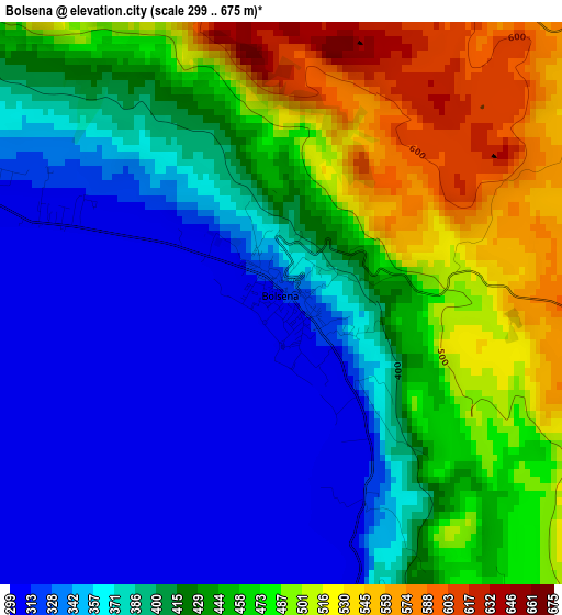
Below is the Elevation map of Bolsena, which displays elevation range with different colors. Scale of the first map is from 299 to 675 m (981 to 2215 ft) with average elevation of 414.6 meters (=1360 ft) [note 1]
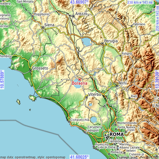
These maps also provides idea of topography and contour of this city, they are displayed at different zoom levels. More info about maps, scale and edge coordinates you can find below images.
| \ | Map #1 | Topo.Map |
| Scale [m] | 299..675 m | × |
| Scale [ft] | 981..2215 ft | × |
| Average | 414.6 m = 1360 ft | × |
| Width | 7.19 km = 4.5 mi | 230 km = 142.9 mi |
| Height | 7.19 km = 4.5 mi | 230 km = 142.9 mi |
| ↑Max Latitude | 42.675577° | 43.66907° |
| Latitude at center | 42.64326° | 42.64326° |
| ↓Min Latitude | 42.610926° | 41.60025° |
| ← Min Longitude | 11.941195° | 10.57889° |
| Longitude center | 11.98514° | 11.98514° |
| →Max Longitude | 12.029085° | 13.39139° |
Nearby cities:
Cities around Bolsena sort by population:
• Montefiascone elevation 570 m
11.8 km,  161°
161°
• Grotte di Castro 478 m
10.2 km,  290°
290°
• Bagnoregio 506 m
8.7 km,  100°
100°
• Sferracavallo 150 m
12.9 km,  44°
44°
• San Lorenzo Nuovo 496 m
8 km,  306°
306°
• Castel Giorgio 551 m
7.1 km,  354°
354°
• Porano 439 m
10.5 km,  66°
66°
• Capodimonte 311 m
12.4 km,  211°
211°
• Gradoli 461 m
10.6 km,  271°
271°
• Castel Viscardo 494 m
12.3 km,  5°
5°
• Latera 521 m
12.8 km,  263°
263°
• Lubriano 444 m
10.1 km,  94°
94°
Multilingual:
 En español:
Lago de Bolsena elevación 316 m.
 En France:
Lac de Bolsena élévation 316 m.
 Auf Deutsch:
Lago di Bolsena höhe über dem Meeresspiegel ist 316 m.

Sources and notes:
- [note 1] Map square and city borders are not equal. Map elevation data is calculated only from area inside that square.
- [src 1] Elevation data from geonames database provided with same terms of usage.
- [src 2] The elevation map of Bolsena is generated using elevation data from NASA's 3 arcsec (90m) resolution SRTM data.
- [src 3] Base (background) map © OpenStreetMap contributors tiles are generated by Geofabrik and OpenTopoMap.
Copyright & License:
This Bolsena Elevation Map is licensed under CC BY-SA. You may reuse any part from this page, if you give a proper credit by linking to this URL:
 More info on terms of use page.