Lubriano elevation
Lubriano (Latium, Provincia di Viterbo), Italy elevation is 444 meters and Lubriano elevation in feet is 1457 ft above sea level [src 1]. Lubriano is a seat of a third-order administrative division (feature code) with elevation that is 122 meters (400 ft) bigger than average city elevation in Italy.
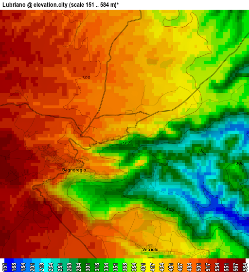
Below is the Elevation map of Lubriano, which displays elevation range with different colors. Scale of the first map is from 151 to 584 m (495 to 1916 ft) with average elevation of 422.6 meters (=1386 ft) [note 1]
These maps also provides idea of topography and contour of this city, they are displayed at different zoom levels. More info about maps, scale and edge coordinates you can find below images.
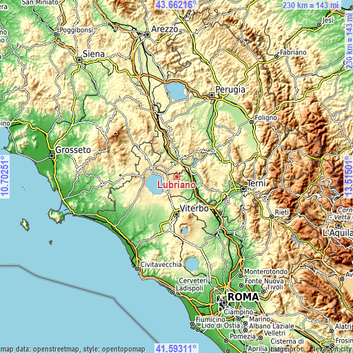
| \ | Map #1 | Topo.Map |
| Scale [m] | 151..584 m | × |
| Scale [ft] | 495..1916 ft | × |
| Average | 422.6 m = 1386 ft | × |
| Width | 7.19 km = 4.5 mi | 230.1 km = 143 mi |
| Height | 7.19 km = 4.5 mi | 230 km = 142.9 mi |
| ↑Max Latitude | 42.668551° | 43.66216° |
| Latitude at center | 42.63623° | 42.63623° |
| ↓Min Latitude | 42.603892° | 41.59311° |
| ← Min Longitude | 12.064815° | 10.70251° |
| Longitude center | 12.10876° | 12.10876° |
| →Max Longitude | 12.152705° | 13.51501° |
Nearby cities:
Cities around Lubriano sort by population:
• Orvieto elevation 315 m
9.2 km,  1°
1°
• Ciconia 124 m
11 km,  10°
10°
• Bolsena 316 m
10.1 km,  274°
274°
• Bagnoregio 506 m
1.8 km,  240°
240°
• Orvieto Scalo 118 m
9.6 km, 12°
• Castiglione in Teverina 254 m
7.9 km,  78°
78°
• Sferracavallo 150 m
10.1 km,  353°
353°
• Porano 439 m
5 km, 354°
• Baschi 172 m
9.8 km,  65°
65°
• Graffignano 196 m
10.1 km,  131°
131°
• Celleno 402 m
8.5 km,  171°
171°
• Civitella d'Agliano 284 m
7.3 km,  120°
120°
Multilingual:
 En español:
Lubriano elevación 444 m.
 En France:
Lubriano élévation 444 m.
 Auf Deutsch:
Lubriano höhe über dem Meeresspiegel ist 444 m.

Sources and notes:
- [note 1] Map square and city borders are not equal. Map elevation data is calculated only from area inside that square.
- [src 1] Elevation data from geonames database provided with same terms of usage.
- [src 2] The elevation map of Lubriano is generated using elevation data from NASA's 3 arcsec (90m) resolution SRTM data.
- [src 3] Base (background) map © OpenStreetMap contributors tiles are generated by Geofabrik and OpenTopoMap.
Copyright & License:
This Lubriano Elevation Map is licensed under CC BY-SA. You may reuse any part from this page, if you give a proper credit by linking to this URL:
 More info on terms of use page.