Porano elevation
Porano (Umbria, Provincia di Terni), Italy elevation is 439 meters and Porano elevation in feet is 1440 ft above sea level [src 1]. Porano is a seat of a third-order administrative division (feature code) with elevation that is 117 meters (384 ft) bigger than average city elevation in Italy.
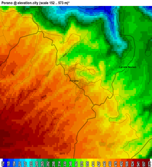
Below is the Elevation map of Porano, which displays elevation range with different colors. Scale of the first map is from 152 to 573 m (499 to 1880 ft) with average elevation of 411.2 meters (=1349 ft) [note 1]
These maps also provides idea of topography and contour of this city, they are displayed at different zoom levels. More info about maps, scale and edge coordinates you can find below images.
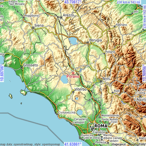
| \ | Map #1 | Topo.Map |
| Scale [m] | 152..573 m | × |
| Scale [ft] | 499..1880 ft | × |
| Average | 411.2 m = 1349 ft | × |
| Width | 7.18 km = 4.5 mi | 229.9 km = 142.9 mi |
| Height | 7.18 km = 4.5 mi | 229.9 km = 142.9 mi |
| ↑Max Latitude | 42.713288° | 43.70617° |
| Latitude at center | 42.68099° | 42.68099° |
| ↓Min Latitude | 42.648676° | 41.63861° |
| ← Min Longitude | 12.059365° | 10.69706° |
| Longitude center | 12.10331° | 12.10331° |
| →Max Longitude | 12.147255° | 13.50956° |
Nearby cities:
Cities around Porano sort by population:
• Orvieto elevation 315 m
4.3 km,  10°
10°
• Ciconia 124 m
6.4 km,  23°
23°
• Bolsena 316 m
10.5 km,  246°
246°
• Bagnoregio 506 m
5.9 km,  190°
190°
• Orvieto Scalo 118 m
5.1 km,  29°
29°
• Castiglione in Teverina 254 m
8.8 km,  112°
112°
• Sferracavallo 150 m
5.1 km,  352°
352°
• Castel Giorgio 551 m
10.7 km,  285°
285°
• Castel Viscardo 494 m
11.6 km,  313°
313°
• Baschi 172 m
9.4 km,  95°
95°
• Civitella d'Agliano 284 m
11 km,  141°
141°
• Lubriano 444 m
5 km,  174°
174°
Multilingual:
 En español:
Porano elevación 439 m.
 En France:
Porano élévation 439 m.


Sources and notes:
- [note 1] Map square and city borders are not equal. Map elevation data is calculated only from area inside that square.
- [src 1] Elevation data from geonames database provided with same terms of usage.
- [src 2] The elevation map of Porano is generated using elevation data from NASA's 3 arcsec (90m) resolution SRTM data.
- [src 3] Base (background) map © OpenStreetMap contributors tiles are generated by Geofabrik and OpenTopoMap.
Copyright & License:
This Porano Elevation Map is licensed under CC BY-SA. You may reuse any part from this page, if you give a proper credit by linking to this URL:
 More info on terms of use page.