Capodimonte elevation
Capodimonte (Latium, Provincia di Viterbo), Italy elevation is 311 meters and Capodimonte elevation in feet is 1020 ft above sea level [src 1]. Capodimonte is a seat of a third-order administrative division (feature code) with elevation that is 11 meters (36 ft) smaller than average city elevation in Italy.
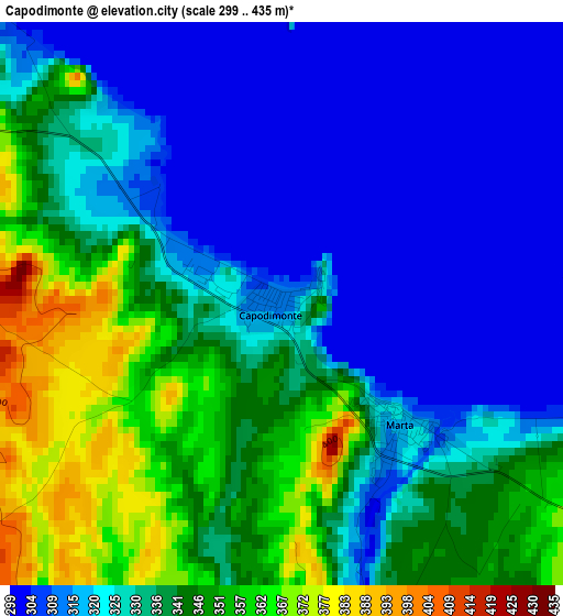
Below is the Elevation map of Capodimonte, which displays elevation range with different colors. Scale of the first map is from 299 to 435 m (981 to 1427 ft) with average elevation of 332 meters (=1089 ft) [note 1]
These maps also provides idea of topography and contour of this city, they are displayed at different zoom levels. More info about maps, scale and edge coordinates you can find below images.
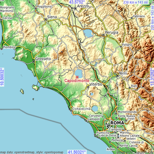
| \ | Map #1 | Topo.Map |
| Scale [m] | 299..435 m | × |
| Scale [ft] | 981..1427 ft | × |
| Average | 332 m = 1089 ft | × |
| Width | 7.2 km = 4.5 mi | 230.4 km = 143.2 mi |
| Height | 7.2 km = 4.5 mi | 230.4 km = 143.2 mi |
| ↑Max Latitude | 42.580167° | 43.5752° |
| Latitude at center | 42.5478° | 42.5478° |
| ↓Min Latitude | 42.515417° | 41.50321° |
| ← Min Longitude | 11.862625° | 10.50032° |
| Longitude center | 11.90657° | 11.90657° |
| →Max Longitude | 11.950515° | 13.31282° |
Nearby cities:
Cities around Capodimonte sort by population:
• Montefiascone elevation 570 m
10.3 km,  93°
93°
• Bolsena 316 m
12.4 km,  31°
31°
• Marta 318 m
2.2 km,  138°
138°
• Valentano 510 m
6.7 km,  285°
285°
• Ischia di Castro 412 m
12.2 km,  268°
268°
• Piansano 429 m
6.8 km,  247°
247°
• Zepponami 435 m
12.3 km,  101°
101°
• Gradoli 461 m
11.6 km,  338°
338°
• Cellere 359 m
11.9 km, 249°
• Arlena di Castro 267 m
11.5 km,  217°
217°
• Latera 521 m
11 km,  325°
325°
• Tessennano 303 m
12.2 km,  230°
230°
Multilingual:
 En español:
Capodimonte elevación 311 m.
 En France:
Capodimonte élévation 311 m.
 Auf Deutsch:
Capodimonte höhe über dem Meeresspiegel ist 311 m.

Sources and notes:
- [note 1] Map square and city borders are not equal. Map elevation data is calculated only from area inside that square.
- [src 1] Elevation data from geonames database provided with same terms of usage.
- [src 2] The elevation map of Capodimonte is generated using elevation data from NASA's 3 arcsec (90m) resolution SRTM data.
- [src 3] Base (background) map © OpenStreetMap contributors tiles are generated by Geofabrik and OpenTopoMap.
Copyright & License:
This Capodimonte Elevation Map is licensed under CC BY-SA. You may reuse any part from this page, if you give a proper credit by linking to this URL:
 More info on terms of use page.