Borgorose elevation
Borgorose (Latium, Provincia di Rieti), Italy elevation is 719 meters and Borgorose elevation in feet is 2359 ft above sea level [src 1]. Borgorose is a seat of a third-order administrative division (feature code) with elevation that is 397 meters (1302 ft) bigger than average city elevation in Italy.
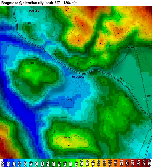
Below is the Elevation map of Borgorose, which displays elevation range with different colors. Scale of the first map is from 627 to 1364 m (2057 to 4475 ft) with average elevation of 860.1 meters (=2822 ft) [note 1]
These maps also provides idea of topography and contour of this city, they are displayed at different zoom levels. More info about maps, scale and edge coordinates you can find below images.
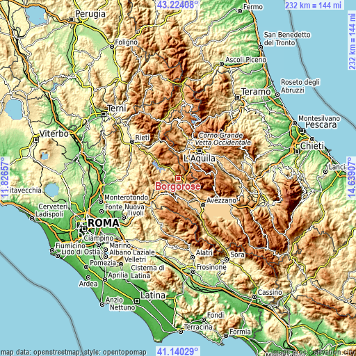
| \ | Map #1 | Topo.Map |
| Scale [m] | 627..1364 m | × |
| Scale [ft] | 2057..4475 ft | × |
| Average | 860.1 m = 2822 ft | × |
| Width | 7.24 km = 4.5 mi | 231.7 km = 144 mi |
| Height | 7.24 km = 4.5 mi | 231.7 km = 144 mi |
| ↑Max Latitude | 42.223321° | 43.22408° |
| Latitude at center | 42.19077° | 42.19077° |
| ↓Min Latitude | 42.158202° | 41.14029° |
| ← Min Longitude | 13.188875° | 11.82657° |
| Longitude center | 13.23282° | 13.23282° |
| →Max Longitude | 13.276765° | 14.63907° |
Nearby cities:
Cities around Borgorose sort by population:
• Tagliacozzo elevation 735 m
13.6 km,  172°
172°
• Carsoli 612 m
15.7 km,  229°
229°
• Magliano De'Marsi 726 m
15.4 km,  135°
135°
• Tornimparte 874 m
12.4 km,  26°
26°
• Corvaro 841 m
3.1 km,  58°
58°
• Lucoli 954 m
14.1 km,  37°
37°
• Villagrande 875 m
12.9 km, 25°
• Pescorocchiano 818 m
7.3 km,  283°
283°
• Sante Marie 863 m
10 km,  194°
194°
• Nespolo 870 m
14 km,  254°
254°
• Fiamignano 1031 m
12.2 km,  312°
312°
• Marcetelli 932 m
15.9 km, 284°
Multilingual:
 En español:
Borgorose elevación 719 m.
 En France:
Borgorose élévation 719 m.
 Auf Deutsch:
Borgorose höhe über dem Meeresspiegel ist 719 m.

Sources and notes:
- [note 1] Map square and city borders are not equal. Map elevation data is calculated only from area inside that square.
- [src 1] Elevation data from geonames database provided with same terms of usage.
- [src 2] The elevation map of Borgorose is generated using elevation data from NASA's 3 arcsec (90m) resolution SRTM data.
- [src 3] Base (background) map © OpenStreetMap contributors tiles are generated by Geofabrik and OpenTopoMap.
Copyright & License:
This Borgorose Elevation Map is licensed under CC BY-SA. You may reuse any part from this page, if you give a proper credit by linking to this URL:
 More info on terms of use page.