Marcetelli elevation
Marcetelli (Latium, Provincia di Rieti), Italy elevation is 932 meters and Marcetelli elevation in feet is 3058 ft above sea level [src 1]. Marcetelli is a seat of a third-order administrative division (feature code) with elevation that is 610 meters (2001 ft) bigger than average city elevation in Italy.
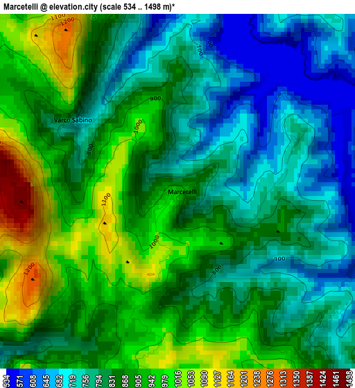
Below is the Elevation map of Marcetelli, which displays elevation range with different colors. Scale of the first map is from 534 to 1498 m (1752 to 4915 ft) with average elevation of 847.1 meters (=2779 ft) [note 1]
These maps also provides idea of topography and contour of this city, they are displayed at different zoom levels. More info about maps, scale and edge coordinates you can find below images.
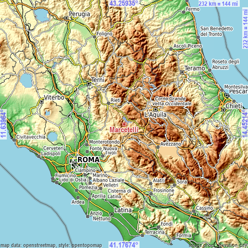
| \ | Map #1 | Topo.Map |
| Scale [m] | 534..1498 m | × |
| Scale [ft] | 1752..4915 ft | × |
| Average | 847.1 m = 2779 ft | × |
| Width | 7.24 km = 4.5 mi | 231.6 km = 143.9 mi |
| Height | 7.24 km = 4.5 mi | 231.6 km = 143.9 mi |
| ↑Max Latitude | 42.259163° | 43.25935° |
| Latitude at center | 42.22663° | 42.22663° |
| ↓Min Latitude | 42.19408° | 41.17674° |
| ← Min Longitude | 13.001945° | 11.63964° |
| Longitude center | 13.04589° | 13.04589° |
| →Max Longitude | 13.089835° | 14.45214° |
Nearby cities:
Cities around Marcetelli sort by population:
• Pescorocchiano elevation 818 m
8.6 km,  105°
105°
• Colle di Tora 561 m
8.4 km,  255°
255°
• Nespolo 870 m
8 km,  166°
166°
• Petrella Salto 778 m
7.7 km,  13°
13°
• Castel di Tora 549 m
6.3 km, 257°
• Pozzaglia Sabino 866 m
10.1 km,  221°
221°
• Fiamignano 1031 m
7.8 km,  56°
56°
• Paganico Sabino 685 m
5.8 km, 224°
• Collegiove 980 m
5.8 km,  186°
186°
• Ascrea 683 m
5.3 km,  232°
232°
• Varco Sabino 756 m
2.6 km,  305°
305°
• Longone Sabino 789 m
8.3 km, 308°
Multilingual:
 En español:
Marcetelli elevación 932 m.
 En France:
Marcetelli élévation 932 m.
 Auf Deutsch:
Marcetelli höhe über dem Meeresspiegel ist 932 m.

Sources and notes:
- [note 1] Map square and city borders are not equal. Map elevation data is calculated only from area inside that square.
- [src 1] Elevation data from geonames database provided with same terms of usage.
- [src 2] The elevation map of Marcetelli is generated using elevation data from NASA's 3 arcsec (90m) resolution SRTM data.
- [src 3] Base (background) map © OpenStreetMap contributors tiles are generated by Geofabrik and OpenTopoMap.
Copyright & License:
This Marcetelli Elevation Map is licensed under CC BY-SA. You may reuse any part from this page, if you give a proper credit by linking to this URL:
 More info on terms of use page.