Corvaro elevation
Corvaro (Latium, Provincia di Rieti), Italy elevation is 841 meters and Corvaro elevation in feet is 2759 ft above sea level [src 1]. Corvaro is a populated place (feature code) with elevation that is 519 meters (1703 ft) bigger than average city elevation in Italy.
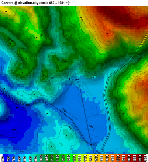
Below is the Elevation map of Corvaro, which displays elevation range with different colors. Scale of the first map is from 680 to 1981 m (2231 to 6499 ft) with average elevation of 1095.2 meters (=3593 ft) [note 1]
These maps also provides idea of topography and contour of this city, they are displayed at different zoom levels. More info about maps, scale and edge coordinates you can find below images.
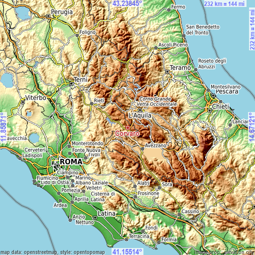
| \ | Map #1 | Topo.Map |
| Scale [m] | 680..1981 m | × |
| Scale [ft] | 2231..6499 ft | × |
| Average | 1095.2 m = 3593 ft | × |
| Width | 7.24 km = 4.5 mi | 231.6 km = 143.9 mi |
| Height | 7.24 km = 4.5 mi | 231.6 km = 143.9 mi |
| ↑Max Latitude | 42.237924° | 43.23845° |
| Latitude at center | 42.20538° | 42.20538° |
| ↓Min Latitude | 42.172819° | 41.15514° |
| ← Min Longitude | 13.221015° | 11.85871° |
| Longitude center | 13.26496° | 13.26496° |
| →Max Longitude | 13.308905° | 14.67121° |
Nearby cities:
Cities around Corvaro sort by population:
• Tagliacozzo elevation 735 m
15.2 km,  183°
183°
• Magliano De'Marsi 726 m
15.1 km,  147°
147°
• Tornimparte 874 m
9.9 km,  17°
17°
• Sassa 684 m
16.5 km,  9°
9°
• Scurcola Marsicana 701 m
17 km,  158°
158°
• Lucoli 954 m
11.3 km,  32°
32°
• Borgorose 719 m
3.1 km,  238°
238°
• Villagrande 875 m
10.4 km, 16°
• Massa d'Albe-Corona 855 m
15.3 km,  135°
135°
• Pescorocchiano 818 m
9.7 km,  270°
270°
• Sante Marie 863 m
12.5 km,  204°
204°
• Fiamignano 1031 m
13.4 km,  299°
299°
Multilingual:
 En español:
Corvaro elevación 841 m.
 En France:
Corvaro élévation 841 m.


Sources and notes:
- [note 1] Map square and city borders are not equal. Map elevation data is calculated only from area inside that square.
- [src 1] Elevation data from geonames database provided with same terms of usage.
- [src 2] The elevation map of Corvaro is generated using elevation data from NASA's 3 arcsec (90m) resolution SRTM data.
- [src 3] Base (background) map © OpenStreetMap contributors tiles are generated by Geofabrik and OpenTopoMap.
Copyright & License:
This Corvaro Elevation Map is licensed under CC BY-SA. You may reuse any part from this page, if you give a proper credit by linking to this URL:
 More info on terms of use page.