Scurcola Marsicana elevation
Scurcola Marsicana (Abruzzo, Provincia dell' Aquila), Italy elevation is 701 meters and Scurcola Marsicana elevation in feet is 2300 ft above sea level [src 1]. Scurcola Marsicana is a seat of a third-order administrative division (feature code) with elevation that is 379 meters (1243 ft) bigger than average city elevation in Italy.
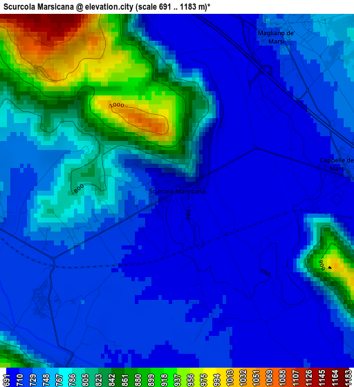
Below is the Elevation map of Scurcola Marsicana, which displays elevation range with different colors. Scale of the first map is from 691 to 1183 m (2267 to 3881 ft) with average elevation of 761.7 meters (=2499 ft) [note 1]
These maps also provides idea of topography and contour of this city, they are displayed at different zoom levels. More info about maps, scale and edge coordinates you can find below images.
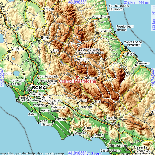
| \ | Map #1 | Topo.Map |
| Scale [m] | 691..1183 m | × |
| Scale [ft] | 2267..3881 ft | × |
| Average | 761.7 m = 2499 ft | × |
| Width | 7.26 km = 4.5 mi | 232.2 km = 144.3 mi |
| Height | 7.26 km = 4.5 mi | 232.2 km = 144.3 mi |
| ↑Max Latitude | 42.095747° | 43.09855° |
| Latitude at center | 42.06313° | 42.06313° |
| ↓Min Latitude | 42.030496° | 41.01055° |
| ← Min Longitude | 13.295245° | 11.93294° |
| Longitude center | 13.33919° | 13.33919° |
| →Max Longitude | 13.383135° | 14.74544° |
Nearby cities:
Cities around Scurcola Marsicana sort by population:
• Avezzano elevation 688 m
8.1 km,  117°
117°
• Celano 742 m
14.8 km,  82°
82°
• Luco dei Marsi 662 m
16 km,  136°
136°
• Capistrello 732 m
11.1 km,  155°
155°
• Tagliacozzo 735 m
7 km,  275°
275°
• Magliano De'Marsi 726 m
3.8 km,  32°
32°
• Castellafiume 879 m
8.2 km,  182°
182°
• Borgorose 719 m
16.7 km,  328°
328°
• Canistro Inferiore 556 m
14.8 km, 156°
• Massa d'Albe-Corona 855 m
6.7 km,  42°
42°
• Sante Marie 863 m
12.2 km,  291°
291°
• Cappadocia 1099 m
8 km,  219°
219°
Multilingual:
 En español:
Scurcola Marsicana elevación 701 m.
 En France:
Scurcola Marsicana élévation 701 m.
 Auf Deutsch:
Scurcola Marsicana höhe über dem Meeresspiegel ist 701 m.
 На русском:
Scurcola Marsicana высота над уровнем моря 701 м
Sources and notes:
- [note 1] Map square and city borders are not equal. Map elevation data is calculated only from area inside that square.
- [src 1] Elevation data from geonames database provided with same terms of usage.
- [src 2] The elevation map of Scurcola Marsicana is generated using elevation data from NASA's 3 arcsec (90m) resolution SRTM data.
- [src 3] Base (background) map © OpenStreetMap contributors tiles are generated by Geofabrik and OpenTopoMap.
Copyright & License:
This Scurcola Marsicana Elevation Map is licensed under CC BY-SA. You may reuse any part from this page, if you give a proper credit by linking to this URL:
 More info on terms of use page.